Do you live near an estuary, where salt and freshwater meet to create a vibrant ecosystem to support the local economy?
While estuaries only make up 4% of America’s land area, they are home to 40% of our population. We are drawn to estuaries because they are rich in biodiversity, economic opportunities, and connection.
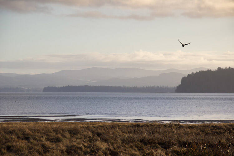
We live in a landscape shaped by water. Without the combination of freshwater and saltwater in Grays Harbor and Willapa Bay, we would not have abundant Dungeness crab, world class oysters, salmon or 600,000 migratory shorebirds visiting our tidelands each year.
This week is National Estuary Week. In partnership with the National Estuaries Program, National Estuarine Research Reserve Association, Restore America’s Estuaries, and other organizations, its purpose is to increase public awareness of estuaries and encourage people to help protect these important coastal resources.
The largest estuary on the U.S. West Coast, the San Francisco Estuary, is about 1,900 square miles in size. The Salish Sea Estuary — made up of Puget Sound, Strait of Juan de Fuca, Georgia Strait, and Desolation Sound in British Columbia — covers 7,200 square miles.
The Chehalis River Estuary (Grays Harbor) is 94 square miles in size, and lies at the mouth of the Chehalis River, which is the second largest watershed in the state of Washington. This site includes subtidal (open water), intertidal (mudflat), rocky shore (harbor mouth), intertidal emergent (salt marsh), intertidal emergent (scrub/shrub), palustrine forested (forested wetland/willow), palustrine emergent (common reed), and palustrine emergent spoil (fill) habitats.
It is a major staging area for migrating shorebirds on the Pacific Flyway, visited by over 500,000 shorebirds during spring and fall. The Estuary also features the 4,494-acre Chehalis River Surge Plain, where cedar and Sitka spruce thrive along tidal sloughs that shelter young salmon and other fish.
Both the Chehalis and Willapa Estuaries are challenged by many factors: low water levels during the summer, high water temperatures, invasive species, and changes in seasonal weather patterns. Timber harvesting, dredging, shoreline armoring, aquaculture and municipal and industrial pollution have altered the character of these estuaries in many ways.
There are similarities and large differences between these two estuaries. These areas are where commercial logging started on the West Coast over 150 years ago. Evidence of early logging is still very evident — thousands of wood pilings remain in the rivers and in both estuaries. Abandoned pulp mills and associated legacy pollution are awaiting cleanup. The watersheds of these two estuaries are among the most important timber harvesting areas of the state, and are among the most heavily logged areas of the state.
Both were, and remain, home to vibrant tribal communities. Both are important cultural and commercial fishing and shellfish farming areas.
The shorelines of the Willapa Estuary are relatively undisturbed, and the population density is low. The Willapa Estuary is often described as “the most pristine estuary in the U.S.” Willapa Estuary is chemically pristine but biologically transformed. New and non-native, often invasive species include: Spartina (cordgrass) Japanese eelgrass, Pacific oysters (the major aquaculture species), Manila clams or steamers (increasingly cultured in Willapa Bay), oyster drills (snails that eat bivalves and barnacles), Eastern softshell clams (previously much more abundant, and now found occasionally at higher tidal elevations), and European green crab. Starting in the 1960s, pesticides like carbaryl were applied to the Estuary to control native ghost shrimp populations. Efforts to control Spartina began in the early 1990s. Mechanical, chemical, and biological techniques are still used.
The Chehalis Estuary has been drastically altered by commercial development. Pier 1 at the Port of Grays Harbor opened in 1922. Prior to that, logs were shipped to the rapidly growing cities on the West Coast. Today, the Port operates four deep-water marine terminals with rail service, as well as related businesses. The shipping channels are actively dredged. The estuary’s shorelines have been drastically altered by placing fill in wetlands and shorelines, and by hardening the shorelines with concrete and rock. Many industries discharge wastewater into the estuary.
Pollution generated in both watersheds ends up in the estuaries. Sources include, but are not limited to sediment from logging and erosion, stormwater discharges, and effluent from sewage treatment plants and industrial sites.
During this week of celebrating the importance of estuaries, I invite you to reflect on why we live here and what we can do protect our scenic estuaries and the abundance they provide us: whether we love to eat crab and oysters, watch birds or work in natural resource related industries.