A high wind warning by the National Weather Service was issued for much of Washington state through Wednesday morning, including Hoquiam, Quinault, Humptulips, Westport, Tokeland, Raymond, Amanda Park, Montesano, Ocean Shores, McCleary, Aberdeen and Elma.
Southwest winds 25 to 35 miles per hour with gusts up to 60 miles per hour were forecast.
Damaging winds will blow down trees and power lines. Widespread power outages are expected. Travel will be difficult, especially for high profile vehicles.
People should avoid being outside in forested areas and around trees and branches. If possible, remain in the lower levels of your home during the windstorm, and avoid windows. Use caution if you must drive.
Once the storm ushers in onshore late Tuesday, gusts will frequently reach 50 to 60 miles per hour, forecasters warn. Farther inland, even blustier conditions will arise throughout the northern Rocky Mountains and surrounding terrain throughout Washington, Oregon, Idaho, Montana and Wyoming by midweek.
Aberdeen School District closures
A warning from the National Weather Service to prepare for a severe storm with damaging winds after 4 p.m. Tuesday has prompted the following cancellations in the Aberdeen School District:
• After school programs – all grades, all schools
• All sports practices
• All athletic events
• AHS band concert
• All evening school events
In addition, the regular meeting of the Aberdeen School Board is postponed to 4 p.m. Friday, Dec. 19.
This will be an abbreviated meeting conducted via Zoom to act on business matters that can’t be postponed to the next regular meeting in January. The in-person option will be set up in the Board Room at the Administration Building, 216 North G St.
For more information, contact the District Office at 360-538-2002.
Atmospheric rivers
Back-to-back atmospheric rivers have doused the Pacific Northwest as of late, resulting in flash flooding, damaging mudslides and major river flooding. Some locations have already picked up over a month’s worth of rainfall within just a few days amid the active weather setup.
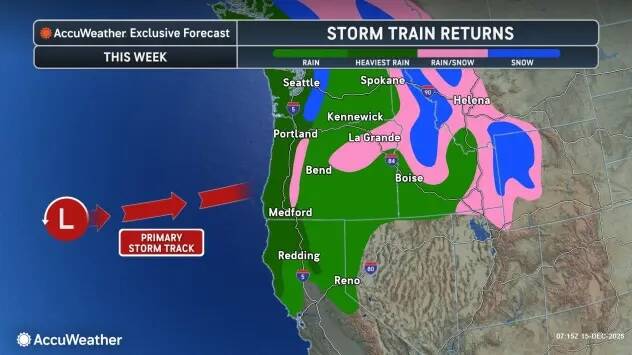
Although the region caught a brief break from the intense storminess this past weekend, conditions won’t stay quiet for long. Another round of storms, including a specific type of atmospheric river known as the Pineapple Express, will affect the region for at least the first part of this week.
This conveyor belt of moisture originates near the Hawaiian Islands, which is how it earns its name, and will transport a relatively warm, humid stream of air toward the northwestern United States that will be capable of producing intense and long-lasting rainfall. Depending on how long these conditions persist, these events can deliver exceptionally high rainfall totals.
This particular event, which began on Sunday night, intensified on Monday and will continue through Wednesday morning, although there will be additional chances of rain and high-elevation snow later this week.
Rounds of rainfall will be funneled into Western Washington and Oregon, as well as northwestern California into Wednesday. In the typically colder spots, rain can mix with snow at times, particularly overnight.
Snow levels began to fall Monday night, especially in Washington. “This can lead to accumulating snow as low as 3,000 feet, which includes Stevens Pass,” noted AccuWeather Meteorologist Alex Duffus.
From Tuesday night into Wednesday morning, a cooler push of air increased the chance of widespread accumulating snow across the region, including Snoqualmie Pass, along Interstate 90.
Another deluge of rainfall to heighten mudslide risk
Steady precipitation will target upslope areas and higher terrain, particularly the Olympic Mountains, the Coastal Range and the Cascades, where 2 to 4 inches of rain is expected. Terrain enhancement may boost totals even further on windward-facing slopes of the Olympics and the Washington Cascades, where amounts upwards of 4 inches are forecast.
Additional rainfall moving into areas that already received several inches over the past week will only worsen ongoing issues. The risk of more mudslides will increase, especially as runoff intensifies through midweek.
“Several inches of additional rain this week, on top of what fell last week, can lead to a renewed risk of major flooding, including on some rivers that crested in record territory,” added Duffus.
River systems that flow out of the Cascades are relatively short and complex because of the variations in terrain.
“Expect multiple, rapid rounds of moderate to major flooding of the short-run rivers in the higher and intermediate elevations of the Cascades this week,” AccuWeather Senior Meteorologist Alex Sosnowski said. “Flooding in the higher elevations can occur in a matter of a few hours. However, where these rivers reach lower, flatter terrain just above sea level, moderate to major flooding can be delayed and longer-lasting and perhaps up to a few days. Multiple crests are likely.”
On Monday, King County emergency managers issued a “Go Now” evacuation alert for residents and businesses east of the Green River after a breach in the Desimone Levee.
“Leave immediately if you are in this area,” the King County Office of Emergency Management said. “Conditions are dangerous, and access routes may be lost at any time. Go north or south of evacuated area away from flooding waters.”
The levee breach prompted a Flash Flood Warning from the National Weather Service in Seattle through Tuesday morning.
Additional storms expected late week
There will only be a minor break following the early-week storm activity before yet another feature crosses into the Pacific Northwest, packing additional rain and snow hazards.
Later this week, parts of Oregon can face the highest risk of additional flooding problems with notable rain expected from Portland to Medford. Travel impacts are anticipated along portions of Interstate 5 as a result, with inundated roadways, downed trees and landslides all on the list of hazards possible.
Given the preceding wet conditions and the substantial amount of additional rain expected throughout the week, there is a possibility for renewed flooding impacts to be catastrophic in nature in some locations.
“As the main focus of the atmospheric rivers shifts southward later this week, the potential for small stream and river flooding will increase substantially farther south in Western Oregon, perhaps in the same manner as that of the Washington Cascades last week and again early this week,” Sosnowski said.
Since the heaviest rain was focused on Western Washington last week, flooding in Oregon was relatively minor, with the majority of incidents concentrated in the northwest part of the state.
The flood watch is in effect from Thursday through Saturday for all of Northwest Oregon and Southwest Washington.
— Alyssa Glenny, AccuWeather Meteorologist, contributed to this report.