A strong-to-extreme atmospheric river stretches 7,000 miles from the Philippines to the Pacific Northwest this week, bringing significant rainfall, high-elevation snow and strong winds to Washington, Oregon, Idaho, Montana and British Columbia starting Monday.
While atmospheric rivers commonly hit the Northwest during fall and winter, the length of this one is very unusual. Spanning the length of the Pacific, this river in the sky is about three times longer than average and among the longest typically observed on the planet.
Hawaiʻi will see little or no impact; the river will span pretty much all open ocean between the Philippines and Northwest.
Weather models also predict that the amount of moisture this atmospheric river will carry will break December records in pockets of Central and Western Washington — raising the risk for flooding rainfall.
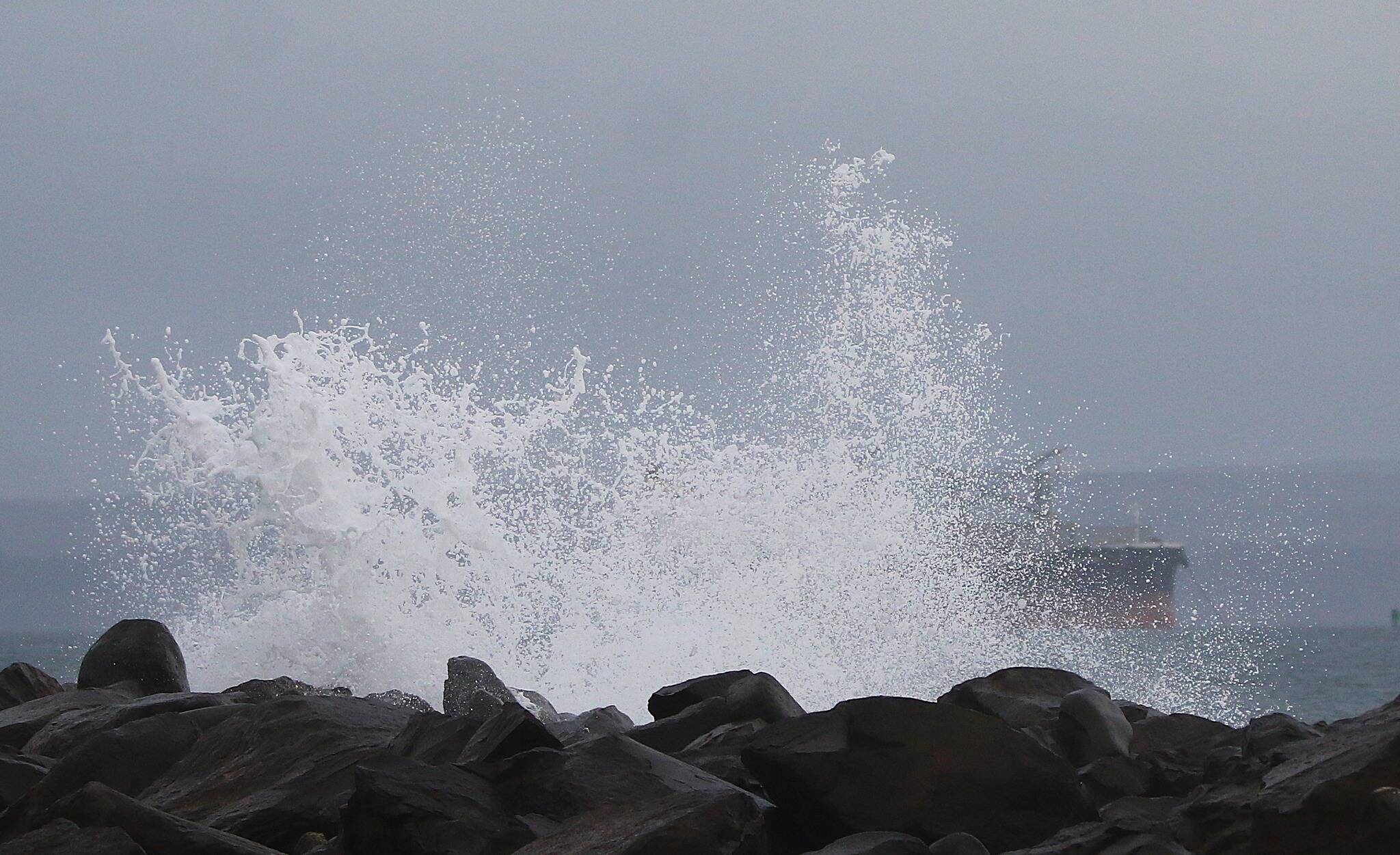
Flood watches span the Cascades and coastal plain from northern Washington to central Oregon, where rainfall totals through Thursday could exceed a foot in the hardest-hit areas, with major flooding possible Wednesday due to near-record-high river levels.
The Skagit, Skykomish, Snoqualmie, Puyallup, Nisqually and Cowlitz rivers in Washington are among those predicted to reach major flood stage, the most extreme level of risk that could bring extensive inundation of structures and roads.
This atmospheric river, whose peak intensity is predicted to reach Category 4 or 5 — with 5 being the highest — on the Center for Western Weather and Water Extremes’ scale, will come in waves, first with the one on Monday followed by another late Tuesday into Wednesday.
The strength of an atmospheric river is determined by how much moisture it transports and its longevity.
Atmospheric river forecast
This atmospheric river will probably be the strongest of the season so far in the Pacific Northwest — stronger than one that caused flooding and localized wind damage in the region during late October.
“People, structures, and roads located below steep slopes, in canyons, and near the mouths of canyons may be at serious risk from rapidly moving landslides,” the National Weather Service in Portland wrote late Sunday.
The dense moisture plume is being carried into the region by storms in the Gulf of Alaska. High pressure near California — which will also contribute to unseasonable warmth — will deflect the atmospheric river to the north, squeezing it into a relatively narrow corridor of the Northwest.
Rain
Flooding rainfall will be the biggest threat with this system. Because of saturated soils, there will be a higher risk for landslides and debris flows on burn scars, the Weather Service in Seattle noted.
The first wave of the atmospheric river built across Western Washington and northwestern Oregon on Monday afternoon and evening, before focusing on southern Washington, northern Oregon and northern Idaho on Monday night.
Moderate rain is expected in the region Tuesday before an intensification, particularly across Washington and northern Idaho, as well as British Columbia, from Tuesday night through Wednesday — when flood risks are forecast to increase. The plume’s intensity is forecast to gradually decrease Thursday, but heavy rain is still possible in Washington, Idaho and Montana.
This atmospheric river is stretching across a swath of the Pacific that experienced a record-breaking marine heat wave this year — and where seas remain warmer than average.
Warm, moist air rising from the ocean helps build the moisture plume, and in a warming climate, the atmosphere contains more vapor, making such plumes richer in moisture.
Winds
Strong, gusty winds coincided with the atmospheric river’s arrival Monday, with wind advisories covering the potential for gusts up to 45 mph in Western Washington and Oregon.
The Weather Service in Portland wrote that the gusty winds combined with very saturated soils will increase the chance for downed trees and power outages.
Snow
Snow levels are expected to remain above 6,000 feet in the Northwest due to the warm air associated with the atmospheric river.
However, snowfall amounts will be prolific because of high levels of atmospheric moisture.
Snowfall near the peak of Washington’s Mount Baker — the snowiest place in the United States so far this season — will probably exceed 5 feet.
Heavy snow will also fall across British Columbia, Alberta and Saskatchewan through the week.
Not just meteorological jargon
The term “atmospheric river” has been around for a while and is rooted in science.
The term is more than 30 years old, as coined in 1992 by Newell et al, though they were originally called tropospheric rivers. They were initially described as long, narrow filaments of water vapor that persist for many days.
As the science advanced, forecasters developed a scale for measuring the intensity of these rivers in the sky. They are now generally predictable days in advance, and people can better understand the important role they play in transporting water to almost all corners of the world.
Interest in atmospheric rivers spiked in November 2021 when several damaging ones hit the Pacific Northwest and has since continued to rise.
How to prepare your home for an atmospheric river
Take a deep breath and brace yourselves. It’s about to get real wet this week.
“Atmospheric rivers are taking aim at us,” said National Weather Service meteorologist Dustin Guy. “For Seattle, that spells very, very wet weather.”
A wind advisory and flood watch converged on Monday as the week kicks off with heavy rain, Guy said. For metropolitan areas, that means flooding in the roadways and small-stream flooding that could make commuting a mess Monday afternoon and into the night.
Flooding in counties across northwest and west-central Washington, including King, Snohomish and Pierce counties, is likely through Friday afternoon. Excessive runoff may occur in rivers coming from the Olympic and Cascade mountains as they get 8 to 10 inches of rain.
“Hopefully by now, people have cleared their storm drains and gutters,” Guy said. “Because that will cause some issues.”
Beyond clearing those drains, take a look at safety tips on how to prepare for heavy rain and flooding. Make sure to prepare an emergency kit stocked with a radio, flashlight, batteries and first aid kit; keep rain gear and warm clothing handy; and never drive into standing water.
High winds could knock down tree branches and cause power outages Monday, Guy said. Portions of northwest and west-central Washington could see south winds of 20 to 30 mph with gusts up to 40 mph through 10 p.m. Monday.
If your power goes out, report that outage and any downed power lines to your utility company, and check out some tips for how to get through an outage. Among the best practices: Use flashlights and light sticks over candles, and pick up floor clutter to avoid stubbed toes.
And keep that phone battery charged. Charge your devices, such as backup batteries and laptops, ahead of time so you can use them to charge other devices later. Turn on low power mode and avoid phone-draining activities. So no online gaming, unfortunately.
And as if that weren’t enough, saturated ground soil topped with all the rain this week could cause landslides, Guy said.
It’s hard to know when and where they may hit, so keep a watchful eye on the hills near your home for signs of land movement.
— The Washington Post and Seattle Times contributed to this report.