The rain that had been forecasted had tapered off before noon so when Miles Heisel arrived at the Historical Seaport for his weekly data collection visit, it was a T-shirt day.
Tennis shoes were swapped for boots and chest-high waders pulled over his shorts. With a white five-gallon bucket of equipment in hand, he headed to a section of Chehalis River shoreline.
As the water quality and habitat monitoring intern with the Coastal Interpretive Center (CIC), Heisel has visited this site, along with nine others throughout western Grays Harbor once a week for the past eight weeks; the 11th site, Hoquiam River site, was visited six times due to accessibility issues.
When he visits each week is fluid, dependent upon the tides and his work schedule, and on average, it takes five hours to collect the data. Regardless of the weather, Heisel is out collecting the data, although on Aug. 3, when there was the tsunami advisory, he had a day off from data collection.
An undergraduate student at Western Washington University, Heisel is majoring in environmental science and works in a lab that studies the behaviors of individuals, such as through bird surveys. Experience he brings to the internship is time spent at a shorebird center outside Aukland, New Zealand, doing shorebird population counts. Another passion is salmon conservation.
“This internship gave me a good opportunity to show up to work in that field and make connections with people,” Heisel said.
This internship is a new grant-funded position that CIC created to fill in a monitoring data gap that Jacob Baker, executive director of CIC, had observed when talking with natural resources partners.
“Last year when the WDFW (Washington State Department of Fish and Wildlife)-coordinated Aquatic Species Restoration Plan opened their estuary module of the entire Chehalis Basin Restoration Program, we became aware that there was a need for more cross jurisdictional research and environmental baseline monitoring,” Baker said.
Since joining the CIC in 2024, Baker has worked to rebuild its educational programming based upon a cradle-to-career model. With the K-12 educational programming available in schools, on-site at the museum, and through outdoor events, the missing piece was the career element.
Seeing the need to collect monitoring data, Baker combined the objectives into this internship, which he proposed to the partners.
“I thought that was just a wonderful opportunity because I know it’s difficult to get field experience, especially when you’re trying to get into the natural resource field,” said Ryan Munes, the refuge wildlife biologist for the U.S. Fish and Wildlife (USFW) Nisqually National Wildlife Refuge complex.
Baker secured funding through the Rose Foundation for Communities and the Environment, which is funded in part, he said, through the settlements companies pay when they violate the Clean Water Act.
“That’s especially relevant (for) the internship program, given we’re monitoring water quality and habitat at different sites around the estuary, and it is being funded indirectly through companies that have historically violated clean water or clean habitat concerns,” said Baker.
Over the course of many discussions during 2024 and into 2025, the group identified 14 data points to collect: some based on creating a broader picture of the environmental concerns around the estuary, some were a concern for specific land managers, and others were thought useful to investigate.
Eelgrass was a data point “because it provides good feeding habitat for young salmon and also can indicate good spawning habitat,” Heisel said.
Munes added monitoring for New Zealand mud snail to the list because they are found on the Grays Harbor National Wildlife Refuge, surprisingly in an area where the fresh and saltwater mix, as they can’t survive in salt water.
“I wanted to make sure Miles was aware of what they looked like, and the precautions that he would need to take so he’s not spreading them,” Munes said.
With a size of 4-6 mm in length, and shell colors of gray to dark brown or light brown, the New Zealand mud snails easily blend into the mud and gravel substrate. Other sites in Grays Harbor County where the New Zealand mud snail is present are in areas of the Lower Chehalis River and Duck Lake.
Another invasive surveyed for is the European green crab, which destroys eelgrass and is the focus of ongoing control efforts throughout Grays Harbor County.
The 11 sites that Heisel visited range from heavily impacted areas, such as the Historical Seaport and the site behind the Walmart parking log, to natural areas such as the Chehalis River Surge Plain Natural Area Preserve; land managers include the Port of Grays Harbor, USFW, and Washington State Department of Natural Resources (DNR).
“We knew from the outset that certain locations had been sampled previously and are contaminated, like at the Seaport,” Baker said. “But it’s good to be able to include everything together. That’s really one of the points here, creating that cross jurisdictional dataset.”
For why one of the sites was included at the Refuge, Munes said, “I’m always interested in the water quality of the water that’s coming into the refuge and so they picked a little stream that was coming into the refuge.”
Having the Chehalis River Surge Plain included in the sites being visited sounded great to Carlo Abbruzzese, who is the natural areas manager with DNR.
“Part of the reason that these sites were set up is to give students and researchers places where they can do work like this,” Abbruzzese said. “It’s totally in line with what we do.”
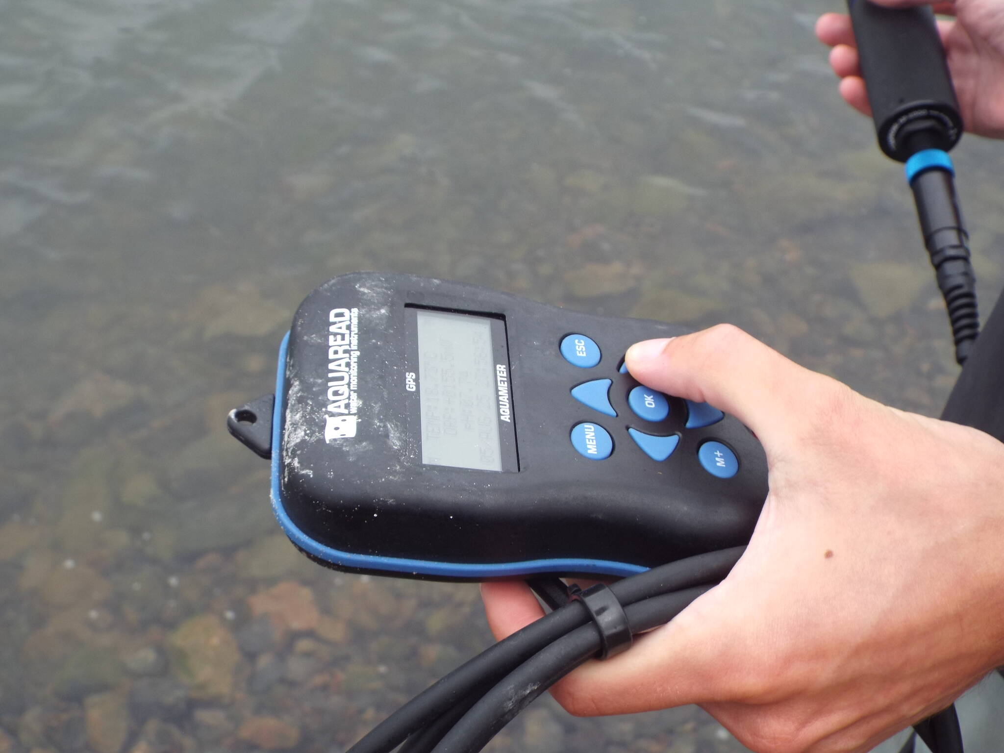
Once at the shoreline, Heisel pulls out an aquameter from the bucket and wades out until the water is about knee high before stopping to lower the probe into the water. The probe has five sensors that measure temperature and pH, nitrate concentration, chlorophyll concentration, salinity and dissolved oxygen. Collectively, these four measurements create a picture of the water quality. For example, chlorophyll is a proxy for the presence of algae, and temperature affects the amount of dissolved oxygen that water can hold and its pH.
“It’s important to collect all of the data rather than just collecting pH because it gives you a more full(er) picture of what’s actually happening in the water,” Heisel said.
At the Historic Seaport and the Chehalis River Plain Surge site, which we will visit next, he doesn’t measure water turbidity. This requires lowering a Secchi disc into the deep water and there’s not a dock that extends far enough into the water to get a good reading. Today, Heisel also doesn’t survey for plastic debris because there’s little mud that he can sift through; this data point will be collected during the next low tide that overlaps with his schedule.
“It does come as a sacrifice of not being able to collect the microplastics data all the time, but if we’re able to collect it once every two weeks, it’s still consistent,” Heisel said.
Today, it only took a couple minutes for the probe to return a reading; earlier in the data collection Heisel could wait for nearly 20 minutes for the readings to stabilize. The water is 19-degrees C and 7.74 pH, “which is pretty normal for most of the sites that I’ve surveyed,” he said. “Some of them get to like around neutral, but most of them stay around like 7.7.”
The chlorophyll reported as 2.66 micrograms, which is a lot lower than normal, Heisel said.
“The chlorophyll sometimes seems to just jump all over the place though, so I’m not entirely sure like what would cause that.”
The method of measuring the chlorophyll is not as accurate as sending a water sample to a lab, he said.
Heisel wades to shore and swaps the probe for a pair of blue gloves. Next is collecting shoreline observations. First, he heads left, walking at the water’s edge roughly 200 meters before backtracking to the starting point and then heading 200 meters to the right.
Methodically, he overturns loose rocks to see if European green crabs might be hiding underneath. And they are in the area because Heisel has found molts.
“The molts are actually the more reliable indicator most of the time,” he said, adding with a laugh, “They don’t run away from you. It’s a lot easier to identify them.”
For each visit, Heisel goes through the checklist in the same order to maintain consistency. And on most days, he’s usually the only person about. Earlier in the data collection while surveying the shoreline, a family of spotted sandpipers would walk up and down the nearby stretch of rocks and scream at him because their chicks were nearby. One would even perch on a plastic chair as it screamed. The chicks have now fledged, and Heisel is sad to see they have gone. The chair is gone too.
Collecting bird observations is last on the checklist, and it’s his favorite part of the data collection. Setting the time on his phone to five minutes, Heisel listens and scans the sky. He considers himself a birder but it’s a hobby.
“I can hear belted kingfisher,” he said. “There’s two rock pigeons. Something over there, that looks like another rock pigeon.”
The belted kingfisher then flies overhead. A California scrub jay calls out. Seagulls on the other side of the river are noted.
The songs are audible over the U.S. Highway 12 traffic, which has been constant background noise. A killdeer and raptor observed earlier doesn’t count since only those birds observed or heard during these five minutes.
The timer dings and six species were noted: belted kingfisher, California scrub jay, American crow, song sparrow, pigeons and seagulls. The count is expected, as “this site doesn’t normally have the craziest bird activity going on,” Heisel said.
Returning to the car, Heisel’s hiking boots are taken off to be scrubbed and sprayed, first off with water to remove the mud and then sprayed with a 2% Virkon Aquatic, a disinfectant, which is designed for use in aquatic environments. This is standard protocol upon finishing the survey at each site.
“The mud snails can live in very small clumps of mud, and they also live outside of water for up to 50 days,” Heisel said. “You have to be very careful about them, especially if you know if there’s any sites that they’re a problem (at), which we have two that they are potentially a problem at.”
Then he sits for 15 minutes, which is how long the gear needs to remain moistened, before they can be sprayed off with another round of water. Heisel fills out the hardcopy data sheet as we wait, entering the start and stop time, the weather conditions, and amount of observed woody debris. This information will then be entered into an Excel spreadsheet.
When the 15 minutes up, the equipment is stowed, (Heisel brought an extra pair of tennis shoes) and about a 15-minute drive to the Chehalis River Surge Plain site for the next round of sampling.
Here there’s a couple of cars in the parking lot and a couple is walking nearby. In the times when there are people around when Heisel is collecting data, he said that most of the interactions have been positive. “There are people who are literally like, ‘Thank you, thank you for doing this work,’” he said. “And that’s really cool.”
Heisel heads to the boat launch for the data collection. He repeats the same set of measurements as best he can given the different site conditions; the deeper water along the grass-lined shoreline means he can’t walk that far to survey for European green crab. In addition to surveying the boat launch area, he takes a nearby trail that dead ends at the shoreline and does a visual survey there.
Although the trash he sees isn’t documented, Heisel has taken note of what he’s found. At one site was an iPhone on the rocks, golf balls at Bill’s Spit in Ocean Shores and behind the Walmart parking lot were AA and AAA batteries and a DVD.
“It definitely has the most interesting garbage,” Heisel said.
Of the birds at the Chehalis River Surge Plain, there’s another kingfisher, and a Steller jay calling from the other side of the river. In total, he counts seven species.
Before his internship ended on Aug. 27, Heisel will have finalized the data into an Excel spreadsheet that will be shared with the partners.
“Having a baseline for water quality can be helpful if things are changing with climate or agricultural practices,” said Abbruzzese. “It’s nice to have at least a baseline from now.”
Additionally, documenting the species of birds at the Chehalis River Surge Plain will also be useful in management.
Another benefit of this type of data collection is it can inform where managers need to direct attention. For example, Heisel found a bed of eelgrass at the 28th Street boat launch in Hoquiam, which he describes as “between two parts of the port that are constantly active with commercial and recreational vessels and whatnot.”
“All the time we’re finding new stuff and it can then inform us for future management decisions,” Munes said.
While at the Historical Seaport, as we search for European green crabs, to the question of how this data collection has given him a view of the Chehalis Basin that most people aren’t privy to, Heisel answers readily.
“It shows me how much work needs to be done to rejuvenate this place and make it into a more suitable habitat for all of the species that swim through here, especially salmon, which are just, (it) cannot be overstated how important they are to the region,” he said. “And though in some ways it’s sobering, it’s also hopeful because I know that there are people who are doing all this work. And even though I’m the only one down here, I know that I’m not actually alone when I’m doing this work.”
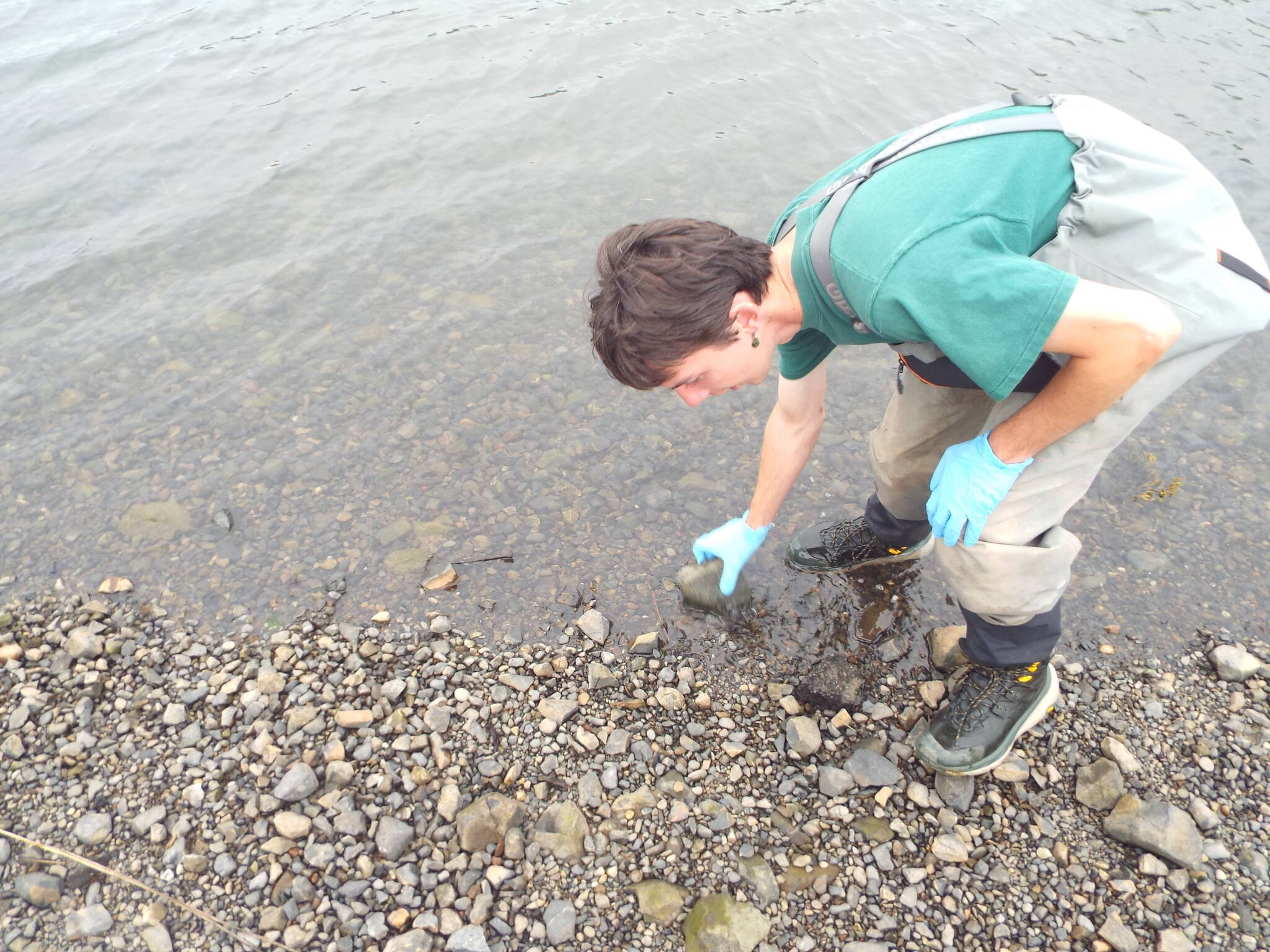
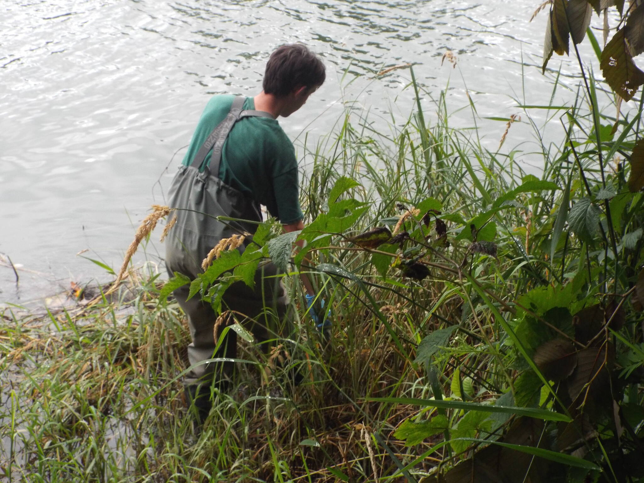
When surveying for European green crab, Miles Heisel overturned loose rocks to see if European green crabs might be hiding underneath. At the Historical Seaport, he’s found molts while surveying, which means they are in the area.
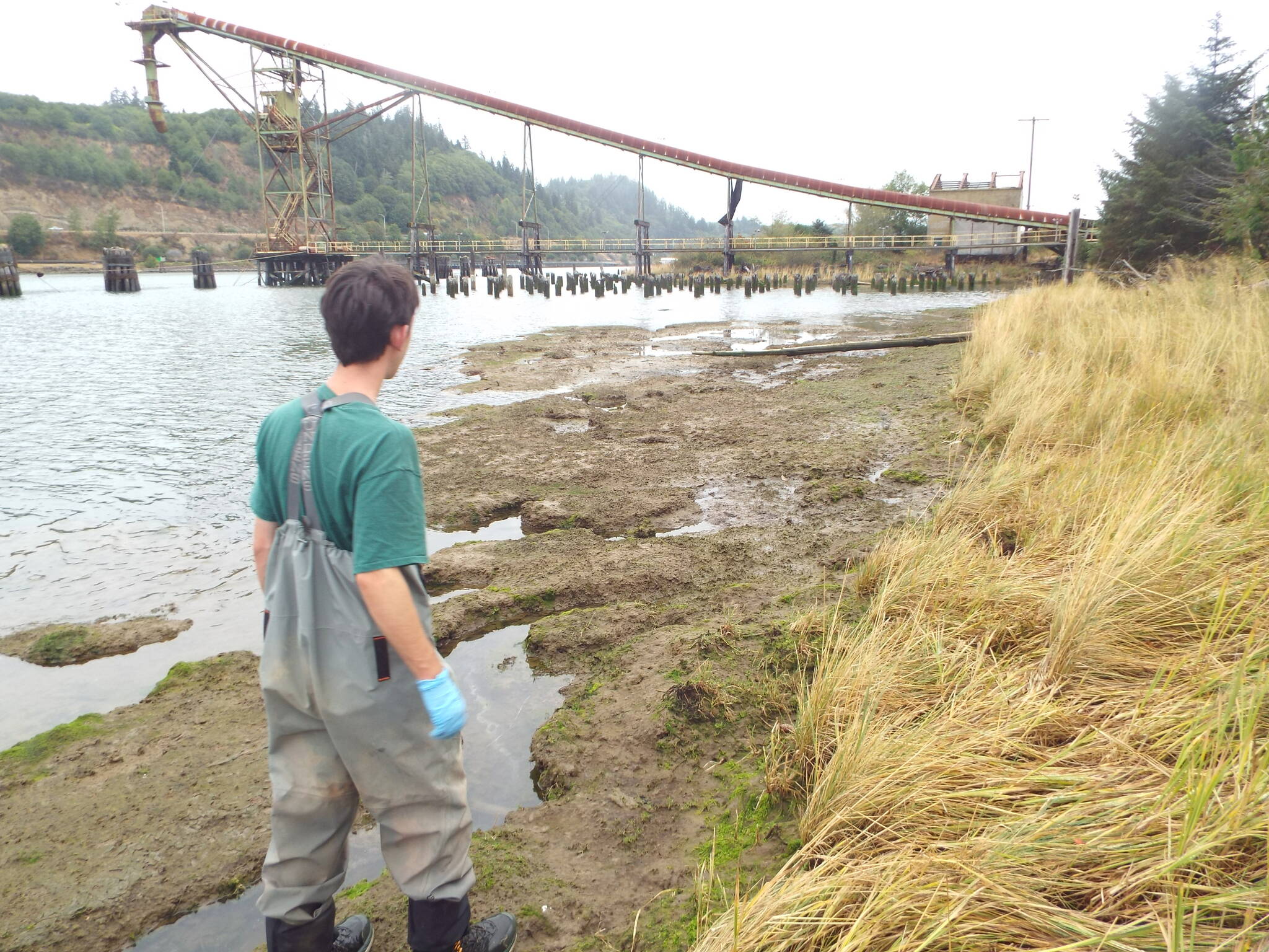
The sites that Miles Heisel visited to collect data include the heavily impacted Historic Seaport.
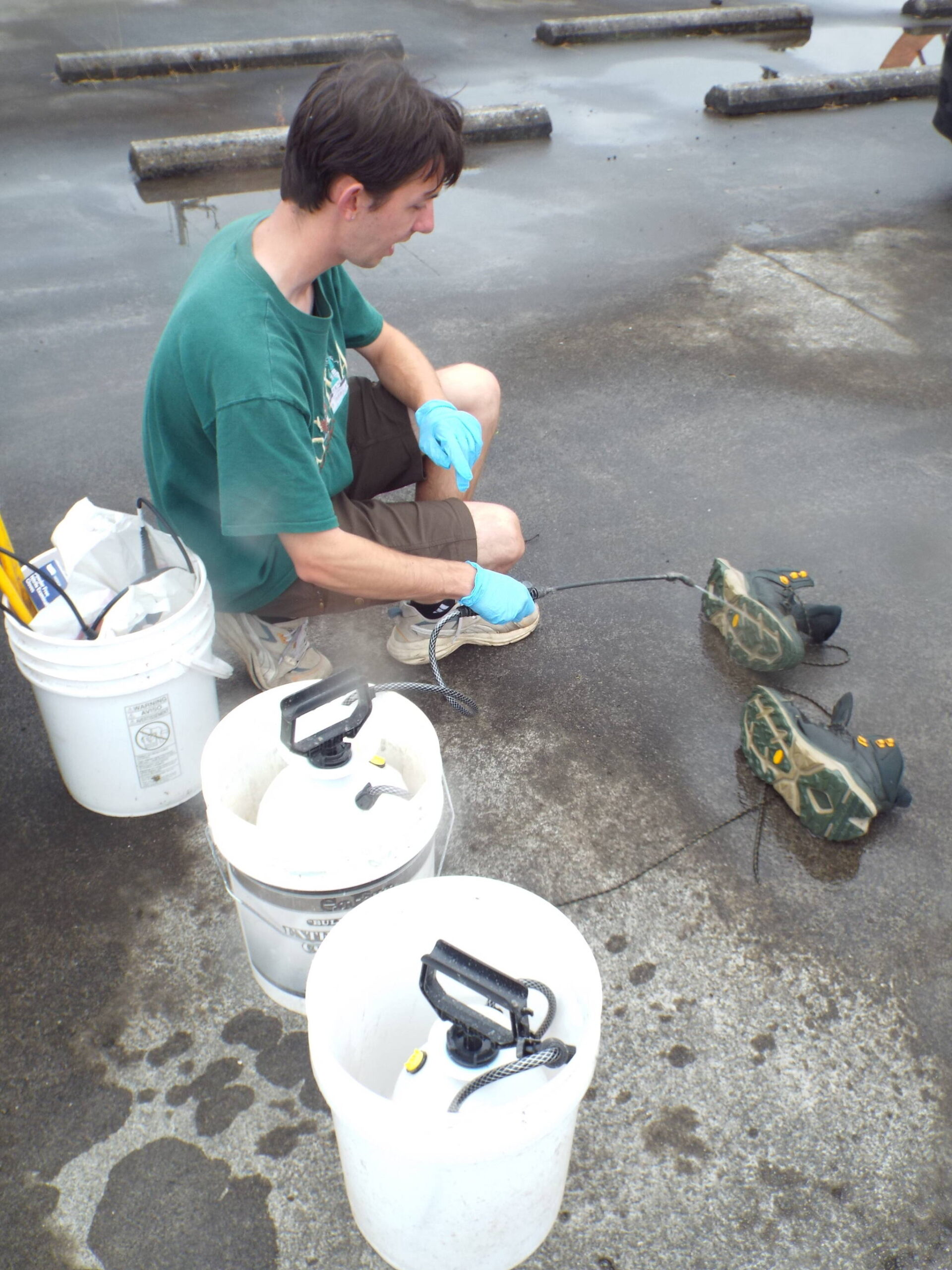
To reduce the risk of contaminating the sites that he visits, Miles Heisel sprayed his hiking shoes with a disinfectant that’s designed for use in aquatic environments. The invasive New Zealand mud snails live in mud and can easily be transported.
Ryan Munes / U.S. Fish and Wildlife During his site visits, Miles Heisel looks for the invasive New Zealand mud snail. These tiny snails, 4-6 mm in length, blend into the mud and gravel substrate.