In search for stronger shoreline, Ocean Shores can look to coastal neighbors
Published 1:00 pm Thursday, November 2, 2023


Editor’s note: This is part two of two in a series about erosion on Ocean Shores’ southern shoreline. Part one outlined the threat of erosion to public and private infrastructure and emergency action from city officials; part two describes the driving factors of erosion, the framework for environmental resilience on the Washington coast, and potential long-term mitigation measures for Ocean Shores.
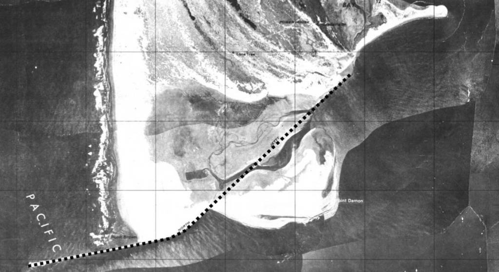
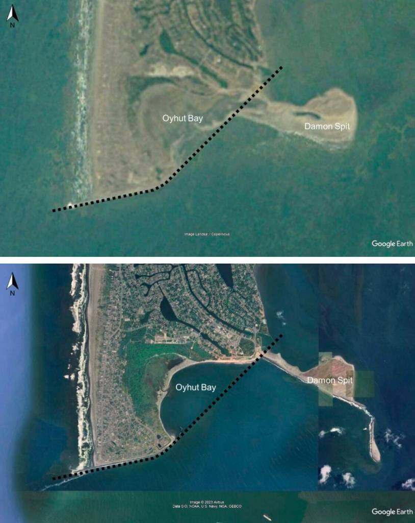
In 1916, the U.S. Army Corps of Engineers completed the construction of Grays Harbor’s North Jetty, a three mile-long berm of boulders jutting into the Pacific, hugging and holding the entire southern shoreline of Ocean Shores. The body of water now known as Oyhut Bay did not exist.
Today, a large remnant of that jetty, roughly 10,000 feet angling to the northeast from the peninsula’s western hoof to the Damon Point parking lot, lies stranded and submerged in the bay, battered by 100 years of bashing saltwater, waves and, once, the impact of an errant fishing boat.
During that time the shoreline has steadily abandoned the old jetty, retreating thousands of feet to the north. Erosion now threatens to cause millions of dollars of damage to public and private infrastructure.
While no environmental factor alone can fully explain the widening gap between the relic rocks and receding beaches, the shoreline owes much of its shape to the jetties protruding into the Pacific at Grays Harbor’s entrance.
“The erosion that you see in Oyhut Bay, and basically the development and expansion of the bay, is part of a very long-term process of the inlet entrance evolving in response to the construction of jetties,” said George Kaminsky, a coastal erosion expert with the Washington state Department of Ecology.
The biggest effect of the jetties, Kaminsky said, is “less sharing of sand going from north to south.” That phenomenon is evidenced by the altered alignment of beaches in Ocean Shores and Westport — the two peninsulas once paralleled each other, but as the North Jetty slowed southward currents and accumulated sand on the beach directly above it, Ocean Shores bulged to the west. From above, the mouth of Grays Harbor appears as a coastal jaw with an overbite.
That was by design — to keep sand out of the middle of the harbor and maintain a deeper channel for entering ships.
“The consequence is that you have deep water next to the shoreline and when the shoreline is no longer protected by the jetty, the shoreline is going to erode because deeper water allows bigger waves; bigger waves strike the shoreline and make the shoreline retreat,” Kaminsky said. “Are we dealing with a natural process? Are we dealing with a partly man made process? Or a combination of both?”
Kaminsky, who has studied coastal erosion in Southwest Washington for three decades, said those questions — the scope of the issue — will be crucial as Ocean Shores examines both emergency and long term solutions for resilience on its southern shoreline.
Currently city officials are scrambling to find an emergency buffer to protect property from forecasted king tides and storm swells this winter. With that measure in place, they’ll look to the future: Those extreme weather events could give a snapshot of rising sea levels due to climate change. In 2019 the University of Washington’s Climate Impacts Group produced a sea level rise predictor with beach-level specificity. For most of Oyhut Bay, the model gives a 50% chance water levels will rise by six inches by 2050, and anywhere from one and one-and-a-half feet by 2100, depending on emissions levels.
Luckily for the city, it’s not starting from square one.
In 2019 the Department of Ecology and Washington Sea Grant, a research institute in Seattle, began a collaboration, called the Resilience Action Demonstration project, hoping to show how state experts could provide technical assistance on coastal resilience projects in coastal communities. During the two-year project, the agencies talked to dozens of leaders in local government, nonprofits, tribes, natural resource committees and others along the coast of Washington.
“Community members and jurisdictional staff who can lead projects are stretched thin and their efforts are made more difficult faced by small and low-income communities,” the project’s final report reads.
Jackson Blalock, who led the demonstration project for Sea Grant and authored its final report, said the project aimed to “facilitate connections in a way that can help communities move from issue to action.”
“It’s not just about the state coming in and saving the day,” he said. “You have to have local participation as much or more than the state.”
The agencies took an inventory of 178 potential coastal hazards including anything from tsunamis to sea level rise to erosion, and eventually picked the three hazards most primed to start scoping projects and apply for funding.
One of those was the erosion at Oyhut Bay, which Ocean Shores city staff and officials discussed with the state agencies at the time. The city’s former mayor, former engineer, and grant writer Sarah Bisson all participated in the demonstration project, which ultimately led to a $150,000 federal grant for the city to commission an assessment to gauge the extent of the erosion. It recently forecasted a grim future for Ocean Shores’ south end without some kind of action.
Collaboration with landowners will be critical, Bisson said. Much of the dune buffer between the ocean and houses below Marine View Drive is private land, and those are the front lines for some kind of erosion mitigation structure, both short and long term.
Right now, city officials are working with other agencies to figure out what exactly erosion prevention should look like. Bisson said funding strategies also won’t be certain until then.
She is aware, however, of other, larger potential grant opportunities with the Federal Emergency Management Agency.
“This study was funded through FEMA, they saw it as a valuable enough project to fund it,” Bisson said. “So I’m hoping they will also see value in assisting us with solutions.”
How much money the city needs will depend on the remedy — or remedies — of choice. The erosion assessment outlines a handful of them, each of which comes with its own price tag, pros and cons. Those include nourishing the beach with sand, building a dynamic cobble berm, rock armoring or a breakwater to dissipate incoming wave energy.
A breakwater solution would likely cost upward of $10 million, the study states, and a cobble berm or rock armoring somewhere in the range of $5 million to $10 million.
As the city looks for solutions, it can learn from similar projects completed in the last decade by coastal neighbors, especially when it comes to the emerging technology of cobble berms — also called dynamic revetments — intended to mimic the energy-absorbing powers of a beach composed of sand and mid-sized stones by shifting naturally upon wave impact.
The performance of these types of nature-based berms is still being studied, but past projects at North Cove, the Shoalwater Bay Tribe and in Westport — each with varying designs — boast anecdotal successes.
“We’re building another wheel, but we’re not inventing it,” said Marshall Read, lead planner for the city of Ocean Shores. “So that’s somewhat encouraging.”
At least partially, the remnant jetty in the middle of Oyhut Bay still acts as a break to oncoming wave energy. The recent study states that installing a new breakwater, or repairing the remnant jetty, would result in less sediment loss during storm events.
In 2024 the Army Corps will begin work on a $17 million federally-funded project to repair about 7,500 feet of the jetty, protecting the west side of the peninsula, including the Ocean Shores wastewater treatment plant. The scope of that project does not include repairs to the old jetty submerged in Oyhut Bay.
Ocean Shores Mayor Jon Martin said working with the Corps both in the short and long term will be key to combating erosion on the southern shoreline. Martin said he hoped to talk with federal representatives to “light a fire underneath the Corps of Engineers to sit down and take our report and overlay with their plan.”
Another important partner, Martin said, will be the Quinault Indian Nation, which owns the Quinault Marina and RV Park on the east side of the bay.
“Without everybody working together — the homeowners, the tribe, federal government, local government — we’re going to lose the south end,” Martin said. “In the past we’ve been able to work together and I think we’re going to be able to work together in the future.”
Contact reporter Clayton Franke at 406-552-3917 or clayton.franke@thedailyworld.com.