Heavy rain expected later this week
Published 5:00 pm Tuesday, December 17, 2019

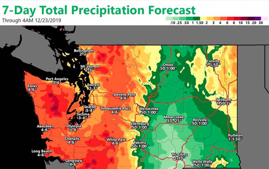


Most of Grays Harbor and Pacific counties could see up to six inches of rain through Monday, even more in the Willapa Hills, with the heaviest expected between Thursday afternoon and early Saturday morning.
“General areas of low pressure off the coast are going to bring a series of storms into our area with a fair amount of moisture,” said National Weather Service Seattle forecaster Brent Bower. “Over the period from Wednesday into Saturday we’re looking at several pulses of pretty strong rainfall.”
The storm series is originating far south in the tropics, where “there’s a lot more moisture than they usually have, bringing a lot of moisture into the area,” said National Weather Service Portland forecaster Amanda Bowen.
Bower said the heaviest rainfall will probably occur Thursday night into Friday and could bring the possibility of river flooding, though as of Tuesday the Wynoochee River wasn’t forecast to crest above flood level, and the Satsop River is expected to come close, but not crest above flood state.
“Depending how it pans out there could be some urban and small stream flooding,” said Bowen. If heavy rains, which will come in bursts, coincide with high tides there is the potential of urban flooding in Aberdeen and Hoquiam, particularly in areas close to the Harbor and the Chehalis River.
In Pacific County, there is also the potential for some flooding, “but it’s really difficult to say exactly what rivers will or won’t flood,” said Bowen. “We’re looking at narrow bands of very heavy rain starting in the afternoon or evening Thursday. Exactly where those bands set up determines where we see the heaviest river flooding.”
The biggest potential for flooding in Pacific County is expected during a 36-hour period between late Thursday and Friday night or Saturday morning, said Bowen.
“Over that period you could see up to four inches in the lowlands and even more than that in the terrain of the Willapa Hills,” she said. That brings the possibility of flooding for any towns in the foothills “right under where the heaviest rains set up, and if it stays there for a while there might be urban flooding.”
There is potential for some strong winds, though the strongest are expected in the northern interior and the San Juans, said Bower. Tuesday night and Wednesday there could be gusts up to 35 mph in Westport, and 15-20 mph in Aberdeen and Quinault.
In Pacific County, breezy conditions are expected between Thursday evening and Friday morning, but Bowen said the current forecast doesn’t indicate major impacts from wind. “We’re expecting the rain to be noticeably out of the ordinary, but for Pacific County it will be just another windy day.”
Rain is expected to taper off Saturday, but continue through the weekend.