Aberdeen could see 3-4 inches of snow through Saturday, more forecast for east county
Published 3:30 pm Wednesday, February 10, 2021


Snow is in the Grays Harbor County forecast for the next four days. Just how much, as usual, depends on where you live in the county and the whims of Mother Nature.
“What we’re looking at here, from about Thursday morning through Saturday is a pair of systems that are coming through. The concern with that is there is likely enough cold air in place (that) most precipitation will fall as snow,” said National Weather Service Seattle forecaster Jacob DeFlitch.
School districts are preparing for the cold weather. Wednesday morning, Aberdeen Superintendent Alicia Henderson announced in-person instruction is suspended Thursday and Friday and that all students should plan for remote-only instruction. Each school district will formulate its own plans, check with each for possible schedule changes.
Current models show the potential for snow starting early Thursday morning with the onset of the first system, the weaker of the two.
“It will be probably starting off on the lighter side, then possibly heavier in the afternoon,” said DeFlitch. “Around the coast it may transition more into rain in the afternoon with some Pacific air being pulled in, it might not be cold enough to stay all snow, but further east, the majority of the precipitation will fall as snow Thursday afternoon into Thursday night.”
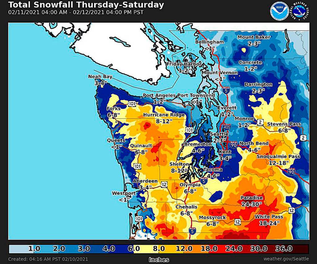
Exact amounts in the first system aren’t certain, but DeFlitch said maybe up to two inches are possible east of Aberdeen, less than an inch from Aberdeen west.
There’s even more uncertainty in the second system, as it has even more potential to drag some warmer Pacific air with it as it approaches during the day Friday.
“Right now it looks to be heavier in the way of precipitation, but it might bring a little more warm air in compared to the first system, especially for Grays Harbor,” said DeFlitch.
DeFlitch said Friday evening through Saturday “we’re sitting anywhere near the two to four inch mark” of snow in Aberdeen and Hoquiam. The east county, such as Montesano, could see 3-6 inches, and higher snow amounts are possible the further east in the county you go.
“Generally the farther away from the water it’s likely to be all snow, closer to the coast the amounts are a trace to two inches” forecast, said DeFlitch.
The systems are also bringing some gusty winds. DeFlitch said they would be peaking into Thursday, with breezy conditions through Friday and possibly into early Saturday. Gusts to 40 mph are possible along the coast, with gusts closer to 25 in Hoquiam.
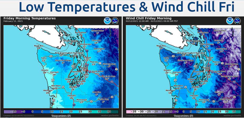
Temperatures will remain cold through the weekend, with a low of 26 in Aberdeen Friday and Saturday mornings. The winds could bring the wind chill down to about 16 degrees. Temperatures will climb some starting Saturday, with a high of 36 in Aberdeen, rising to about 40 Sunday.
Current models show temperatures in the region rising through Sunday and into early next week. Low temperatures will start to rise Sunday as well, around 36 degrees. Monday, rain is back in the forecast with high temperatures in Aberdeen climbing to the mid-40s and lows in the upper 30s.