Office of Chehalis Basin offers January update
Published 1:30 am Wednesday, January 7, 2026


As recent storm systems and river rises have brought flooding and high water levels across Western Washington — including widespread impacts in the Chehalis Basin — being prepared saves money, time, and lives, and we encourage residents to sign up for the Chehalis Basin Flood Warning System to receive timely alerts that can help keep you and your neighbors safe during flood events.
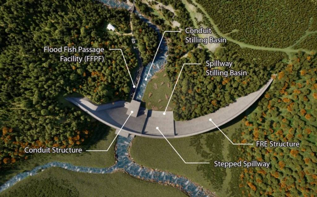
The Office of Chehalis Basin shares updates on recent flood damage and recovery efforts, outline upcoming opportunities for public comment on the Revised Draft Environmental Impact Statement (EIS) for the proposed flow-through flood-control dam and airport levee improvements and introduce the recently released report on the Local Actions Non-Dam (LAND) Alternative. These are all part of the ongoing work to shape a long-term strategy for reducing risk and enhancing resilience in the Basin.
Flood damage and recovery in the Chehalis Basin
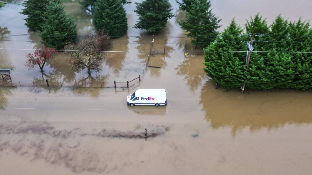
In early December, a powerful atmospheric river brought days of intense rainfall to Western Washington, including the Chehalis Basin, resulting in widespread flooding, impacts to homes and infrastructure, and significant disruptions for families and communities. In response to flooding, landslides, and storm damage beginning Dec. 9, the Trump Administration approved an Emergency Management Declaration for the state of Washington, enabling the Federal Emergency Management Agency (FEMA) to support state, Tribal, and local recovery efforts across multiple counties — including Grays Harbor, Mason, Lewis and Thurston.
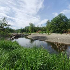
Across the Chehalis Basin, rivers including the Chehalis, Newaukum, Satsop and Skookumchuck reached moderate flood stages, leading to inundated roads, localized evacuations, and access challenges in areas such as the Chehalis Reservation and Grand Mound, and the cities of Chehalis, Centralia, and Napavine. Roads and rural routes were temporarily impassable at times, and emergency shelters were opened to support affected residents.
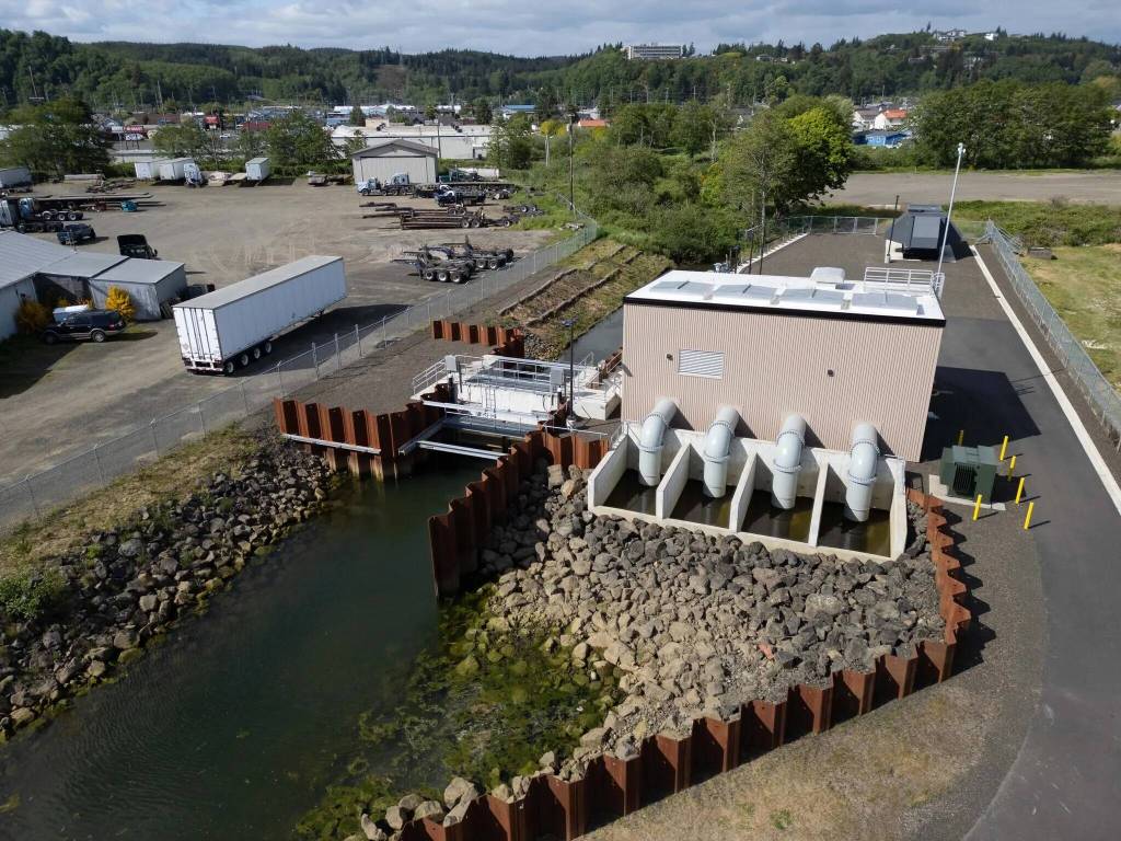
Grays Harbor pump stations
Communities on the coast have also felt the impacts of this historic weather system — Aberdeen and Hoquiam experienced localized flooding as high river and tide conditions combined. Luckily, in 2025 with funding from the Office of Chehalis Basin, the Chehalis River Basin Flood Authority completed two new pump station projects in Hoquiam, doubling the number of new and updated pump stations across the two cities. These two pump stations protect approximately 1,200 homes and businesses and played a part in preventing further damage from the recent flooding events in the cities.
Recovery
While floodwaters have receded, recovery continues. Local emergency management and public works teams are assessing damage, coordinating debris removal, and reopening critical routes, and non-emergency support numbers remain available through county resources.
If your home or business was impacted by flooding, there are probably a lot of things on your mind. Capturing photos and documentation of damage to submit to your flood insurance provider is key as well as getting started on clean-up and repairs. It’s also important to remember that your local government will most likely require permits for any reconstruction, rebuilding, or repair work.
Be sure to contact them before you start any repairs and the staff can provide guidance on next steps. If your house or business is damaged by more than 50%, there may be requirements to bring the building into compliance with current floodplain management requirements.
“We extend our deepest thanks to the local emergency responders, fire districts, public works crews, law enforcement, volunteers, and community partners who worked around the clock to assist residents, manage road closures, facilitate safe evacuations, and support recovery efforts throughout this event,” the agency stated.
Upcoming opportunities for public comment
The Washington State Department of Ecology released a revised Draft Environmental Impact Statement (EIS) in November for the proposed flow-through flood-control facility on the Chehalis River and improvements to the Chehalis–Centralia Airport levee. The revised draft EIS is an informational document and will be considered by the Chehalis Basin Board in decision-making as part of the Chehalis Basin Strategy, alongside other technical studies.
Ecology is accepting public comments on the revised draft EIS through Feb. 4, 2026, by regular mail, online, in person at a public hearing, or virtually through Zoom. Upcoming opportunities for in-person and virtual public comment include:
Jan. 13 at 5:30 p.m. (in-person) in Aberdeen at the Rotary Log Pavilion
Jan. 21 at 5:30 p.m. (in-person) in Boistfort
The most up-to-date information on hearings, how to submit comments, and access to the full draft revised EIS can be found on Ecology’s project webpage.
Local Actions Non-Dam Report now available
The Office of Chehalis Basin announced the release of the Chehalis Basin Local Actions Non-Dam Alternative (LAND) Conceptual Alternatives Analysis Report. Developed by a collaborative team of Chehalis Basin Board members, local residents, and environmental organizations, the LAND alternative explores a non-dam approach to reducing flood damages in the basin.
An initial 2024 report found that, if adopted and built, the LAND alternative could provide significant flood damage protection in the upper Basin, potentially lower flood-insurance premiums, improve emergency evacuation routes, and create some recreational opportunities.
The newly released report marks an early design milestone, refining conceptual levee designs for features including levees, floodwalls, and drainage improvements that could protect homes and businesses while balancing cost effectiveness, natural processes, and emergency access during flood events. The updated concept also removes the previously included diversion on the Chehalis River due to cost, environmental, and stakeholder concerns.
If the Chehalis Basin Board does recommend some or all of the proposed components in the LAND concept for the long-term Chehalis Basin Strategy, it would still take several years to determine the project’s feasibility and design. The next phase of work will focus on additional technical analysis and design of alignments, identifying a local sponsor, environment review, obtaining permits, and securing funding.
Throughout the process, there will be opportunities for engagement, including discussions with potentially affected landowners and public comment periods associated with environmental review.