Sea Level Rise Study presented to Commissioners
Published 1:30 am Wednesday, March 12, 2025


The Grays Harbor County Board of Commissioners consisting of Georgia Miller, Rick Hole and Vickie Raines got their first opportunity to learn about the ongoing Sea Level Rise Vulnerability Assessment and Adaptation Study.
Appearing in person at the meeting, Grays Harbor County Principal Planner Jane Hewitt introduced Younes Nouri, Ph.D., PE, a coastal engineer with Moffatt & Nichol, and the study to the Board. Nouri, who participated via Zoom, then gave a comprehensive presentation regarding the study, which is completely funded by a $130,000 shoreline planning competitive grant from the Washington State Department of Ecology.
“We selected Moffatt & Nichol as our vendor for this project, our consultant Younes Nouri is online and he is going to do a slide deck to get you up to speed on where the work is so far,” Hewitt said.
Nouri, the project manager for the study, proceeded to provide an overview of the ongoing work, key findings and detailed the next steps. The presentation was intended to cover the background and motivation for the study, introduce the study team and discuss funding sources, and outline the goals, scope, schedule and study area as well as highlight key community engagement efforts.
“A recent study by the National Oceanic and Atmospheric Administration showed that when compared to all other coastal counties in Washington, Grays Harbor County ranks second in terms of the percentage of its population living in low-lying areas and first in the actual number of people exposed to coastal flooding risks,” Nouri said. “This highlights the county’s vulnerability and underscores the importance of proactive planning to address current and future sea level rise impacts.”
Nouri said the main question for the study was, “How can Grays Harbor County plan to protect low-lying communities in unincorporated areas, important natural resources and critical infrastructure from rising sea levels and mitigate future conditions projected from climate change hazards?” He indicated the study aims to answer that question and develop a strategy for long-term resilience.
According to Nouri, the study is being led by the Grays Harbor County Planning Division, with support from consultants and a Technical Advisory Committee consisting of personnel from Grays Harbor County Emergency Management, Washington Department of Transportation, Washington Department of Ecology, U.S. Army Corps of Engineers, University of Washington, Grays Harbor Conservation District, Pacific County Conservation District and the Chehalis Basin Collaborative for Salmon Habitat.
“This team provides expertise on emergency management, transportation, ecology and adaptation planning,” Nouri said. “The goal is to develop a roadmap for addressing sea level rise in Grays Harbor County and come up with actionable efforts that the county can advance.”
The presentation stated that the overarching goals of the study are to “assess risks and develop strategies and manage sea level rise, update local plans and regulations to address these challenges, engage with the community and stakeholders for input and feedback, identify and prioritize projects to mitigate hazards and seek funding opportunities for these initiatives.”
The project study area includes unincorporated areas of Grays Harbor County except tribal reservations and areas with their own shoreline master plans. The study administrators conducted numerous site visits in December 2024 and January 2025 and met with stakeholders.
“These visits provided first-hand insights into coastal hazards,” Nouri said. “It helped inform our vulnerability assessment.”
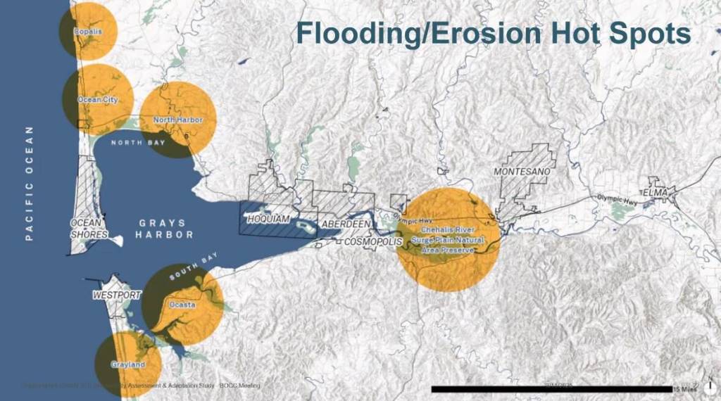
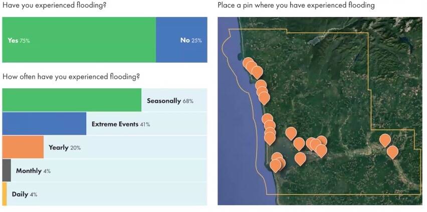
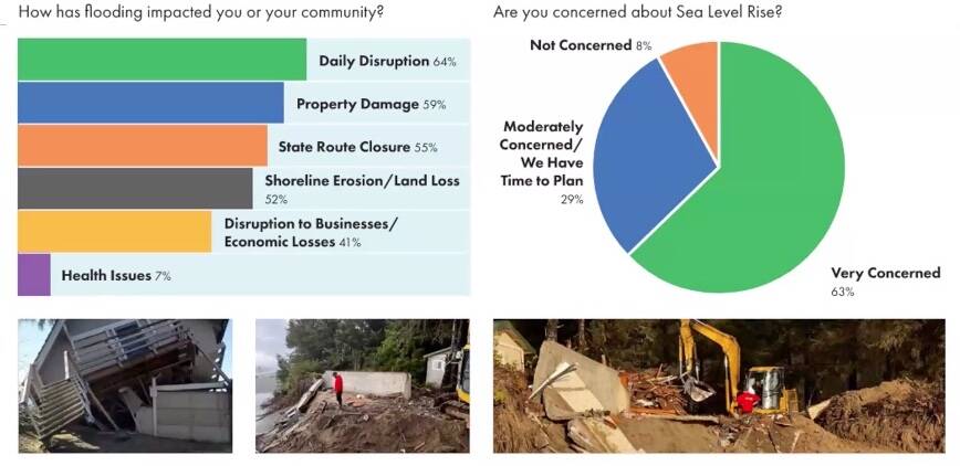
The study also recently conducted a public survey and encouraged local residents to answer a battery of questions regarding the impact of flooding on their daily lives. Nouri highlighted flooding and erosion “hot spots” in Copalis, Ocean City, North Harbor, Ocosta, Grayland and the Chehalis River Surge Plain Natural Area Preserve.
“Our analysis has identified key flooding and erosion hot spots based on the feedback that we received from the community,” Nouri said. “These areas face recurring coastal hazards that will worsen with sea level rise requiring targeted adaptation measures.”
The study team has also been conducting an inventory of critical assets, community lifelines, private properties, businesses, natural resources and recreational areas.
“Understanding what’s at risk helps us prioritize adaptation efforts,” Nouri said. He went on to explain the generational impact sea level rise will have on the residents of Grays Harbor County.
“In summary, this study is a critical step or first step in preparing Grays Harbor County for the impacts of sea level rise,” Nouri said. “By combining science, community input and strategic planning we can develop a path forward that protects people, infrastructure and your natural resources.”
A draft of the Vulnerability Assessment will be presented to the Technical Advisory Committee before the end of March and a public meeting will take place sometime in April to share the findings.
Members of the public are encouraged to share photos of flooding and erosion with the study administrators. The study is scheduled to be completed in June 2025, as required by the grant. The informational website can be found at https://publicinput.com/t22782.