Saturday’s electrifying thunderstorms were highly unusual — and not likely to repeat any time soon
Published 1:30 am Tuesday, September 10, 2019
By Sandi Doughton
The Seattle Times
For a place that doesn’t normally get thunderstorms, Western Washington put on an impressive sky show Saturday evening — a feat meteorologists say is not likely to repeat any time soon.
The National Weather Service counted more than 2,200 cloud-to-ground lightning strikes between 6 p.m. and 11 p.m., a rate of 440 an hour. Though the agency doesn’t keep records on lightning, that’s “pretty remarkable,” said NWS meteorologist Jeff Michalski.
“Any time we have thunderstorms in this region it’s a very rare occurrence.”
Residents across the Puget Sound area posted pictures of lightning bolts stretching horizontally across the sky and illuminating sheets of rain. The weather service noted rumbles of thunder lasting more than 30 seconds, while at least three bolts appeared to strike near the agency’s Sand Point office.
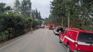
The pyrotechnics delayed by two hours the University of Washington Huskies football game against the California Golden Bears and knocked out power to thousands of households from Whatcom to Pierce counties. Fairgoers dashed for cover at the Washington State Fair in Puyallup, which shut down rides, canceled the evening’s rodeo and concert and closed early.
Thunderstorms are unusual in the Pacific Northwest, where cool, relatively dry air off the Pacific normally prevails and prevents the types of temperature gradients and moisture levels necessary to brew up towering clouds, convection and lightning.
“Normally, our clouds are just sort of low,” Michalski said. “You need a storm to grow to 30,000 or 40,000 feet to produce lightning and generally we just don’t get that depth of storms.”
While Florida averages about 100 thunderstorm days every year, Western Washington gets only five to 10, which ranks among the lowest levels in the country.
The impetus for Saturday’s exceptional light show was a sharp system, called a negative tilt trough, that swept like a wave through the upper atmosphere and coincided with unusual levels of moisture and instability. “It was just sort of perfect timing,” Michalski said.
The result was the explosive development of thunderclouds that reached up to 36,000 feet high. “Normally, we get excited when tops get to 20,000 feet,” UW meteorologist Cliff Mass wrote on his blog.
The storms brought drenching rain and even hail in a few places, including Bothell and Puyallup. At Sea-Tac Airport, 0.59 inches of rain fell, shattering the previous record for the day of 0.26 inches in 2010.
A direct lightning strike to a transformer in Tacoma’s Hilltop neighborhood, along with other damage, knocked out power to more than 12,000 customers. By noon Sunday, Seattle City Light was still reporting 187 active events affecting 1,370 customers. Puget Sound Energy crews were dealing with nearly 100 mostly small outages, affecting about 500 customers primarily in Whatcom County.
“Most of the outages were on account of lightning strikes on the line … transformers being damaged and, in many cases, lightning hit trees, which fell on the line,” said PSE spokesman Nick Hartrich.
More thunderstorms are possible through Sunday, but nothing as intense as Saturday night, Michalski said. “Showers in general are going to be more scattered, and we can’t rule out a few thunderstorms developing.”
And while he won’t go so far as to say summer is definitely done for, the forecast doesn’t look particularly promising for lovers of sun and warmth. High temperatures through Tuesday are expected to hover in the high 60s, with clouds and showers. By Wednesday and Thursday, things should be a bit drier with projected highs in the low 70s under partly cloudy skies.