Planning work continues on Hoquiam flood protection levee
Published 1:30 am Thursday, July 29, 2021

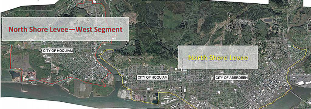


The Hoquiam City Council has approved a $4.4 million agreement with an engineering firm to keep the North Shore Levee—West Segment on track for construction by the end of 2023.
“Moving forward is huge news,” said City Administrator Brian Shay, on the flood protection project that takes off from where the North Shore Levee leaves off, protecting 2,000 Hoquiam properties, 360 businesses, and removing $1 million in annual flood insurance premiums from the community.
HDR Engineering was selected by the city to begin final design, permitting, and right-of-way on the project, part of the larger Aberdeen-Hoquiam Flood Protection Project that includes the North Shore Levee and Fry Creek Pump Station.
“Aberdeen and Hoquiam are working diligently with the goal of having both segments of the levee projects shovel ready for construction by the end of 2023,” read a report from Shay to the City Council on Monday. The total cost of the West Segment is estimated at $40 million.
Multiple funding sources are being sought by both cities for the flood control projects, and Hoquiam has existing and anticipated funds for the$4.4 million-plus HDR agreement.
“Funding for these services is anticipated to come through several sources,” read Shay’s report. “The Office of the Chehalis Basin currently has $4 million in their draft budget allocated to the West Levee. It is anticipated that they will adopt their budget by the end of September if not sooner.”
As previously reported in The Daily World, a federal capital budget request sponsored by Congressman Derek Kilmer for flood control projects in both cities that was submitted earlier this year was passed out of the House Appropriations Committee at $9.95 million.
“We are hopeful that the funding request will reach final approval in the near future,” read Shay’s report. “Aberdeen and Hoquiam will work together to decide how these specific grant funds should be allocated to maximize the needs of the Aberdeen-Hoquiam Flood Protection Project as a whole.”
In late 2020, Hoquiam submitted a $34,650,746.20 federal grant to FEMA for the West Segment. A final decision on that application is anticipated by October, said Shay.
“The City currently has $12,000 remaining from the grant to complete the preliminary engineering/Conditional Letter of Map Revision and over $400,000 remaining in city funding that was included in the City of Hoquiam’s 2021-2022 Budget,” read Shay’s report.
The City Council unanimously gave Mayor Ben Winkelman the authority to enter into the necessary agreements with HDR, and that “HDR be given notice to proceed to utilize existing funds until such time that the anticipated grant funds become available.”
The North Shore Levee would run from the north city limits to the west side of the Wishkah River, along the north bank of the Chehalis River, and east to the east bank of the Hoquiam River. The West Segment would continue from the west bank of the Hoquiam River at the north city limits, south to the Simpson Avenue Bridge, then west and north to State Route 109 west of the high school, protecting the city’s schools and downtown.
“I think a good segment of our community was concerned they weren’t part of” the original North Shore Levee design, said Winkelman. “Seeing progress on the West Segment is inspirational to me.”
According to a fact sheet prepared by the city as it seeks funding, the 4.7-mile levee would maintain 450 jobs and create new jobs, and protect $200 million in public and private investments.
The city claims that, while paying mandatory flood insurance premiums over the last 40 years, less than $2 million in total claims have been paid out to the community. The additional burden of flood insurance premiums, the city said, has been a factor in the loss of about 300 Hoquiam jobs in the past four years alone.