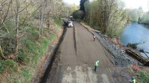
Laying out complex, controversial step of North Shore Levee Project
Published 5:45 pm Monday, April 15, 2024
Homeowners living in North Aberdeen near Wishkah River are angry about the city of Aberdeen’s lack of communication in regard to the North Shore Levee Market Street Alignment.
Worried about losing their homes, the residents questioned the city’s ability to do this the right way. That right way, to them, would have included more community outreach, besides the open house in November. Nick Bird, Aberdeen’s city engineer, addressed some of the concerns the affected residents brought up during the first public comment period, before his presentation last week.
“The citizens are 100% right,” Bird said. “I did not communicate with them and I sincerely apologize.”
While the alignment is a key step to advancing the North Shore Levee Project, for the homeowners who may have to move to make it happen, what help is for them?
According to city documents, Bird brought forth the recommendation. The request was made for parts of the “Preferred Alternative Development.”
Bird gave a presentation Wednesday night, which laid out the various positives and negatives of each of the alignment alternatives. Those positives and negatives revolved around issues with traffic, and issues with a flood wall to the left, right, or center of East Market Street. They dealt with cost, property acquisition, parking, access to Market Street, utility impacts — such as sewage, and right of way impacts, and scheduling.
The alignment alternatives, with specifications and advantages and disadvantages for each — available on the April 10 city council agenda, included:
MARKET STREET NORTH
This alignment keeps the original alignment, effectively constructing a concrete flood wall along the north side of Market Street
Rough order of magnitude cost: $25 million, plus-minus 15%
Advantages
Consistent with previous messaging
Only four driveways impacted
Moderate utility relocation effort
Disadvantages
11 cross-streets, impractical to have closures at all
Requires permanent street closures to be cost-competitive
Most property acquisition for Market Street alignments
Street parking eliminated
Market Street inaccessible prior to, during, and after flood event
MARKET STREET CENTER
This alignment places a concrete flood wall in the center of the roadway between the bi-directional travel lanes
Rough order of magnitude cost: $25 million plus-minus 15%
Advantages
Lowest right of way impacts
Minimizes closures
Least significant utility impacts of Market Street options
Easy access for operation/maintenance
Disadvantages
Crossings require intersection control
U-turns required to access homes/side streets
Street parking impacted
MARKET STREET SOUTH
This alignment places a flood wall along the southern side of Market Street
Rough order of magnitude cost: $25 million plus/minus 15%
Advantages
Access at intersections maintained
Larger street width open during flood event
Disadvantages
22 driveways, three cross-streets, impractical to have gates at all
Most significant utility relocation effort
Moderate property acquisition requirement
Street parking impacted
Potential for accidents when packing out of driveways
MARKET STREET SOUTH, FREE VIEW
Using a passive FloodBreak product called Free View, a barrier system can serve as a pedestrian pathway along the southern side of Market Street
Rough order of magnitude cost: $32 million plus/minus 15%
Advantages
Minimal visual impact
Automatic operation (less operations and maintenance burden)
Can function as a sidewalk
Disadvantages
Prior applications are pedestrian — driveways need to be reviewed
Parked cars need to be moved for system to operate
Durability after 25-plus years
RELOCATION OPTION
This alignment constructs an earthen vegetated berm south of Market Street
Rough order of magnitude cost: $28 million plus/minus 15%
Advantages
Minimizes unprotected properties
Minimizes disruption to Market Street
Provides opportunities for public amenities/access
Provides opportunities for environmental migration
Lowest operation/maintenance burden
Simple construction and no utility impacts
Disadvantages
Longer schedule
Complex negotiations
Short-term public acceptance
Property acquisition and relocation will be required
WISHKAH RIVER ALIGNMENT
This alignment constructs a sheet pile flood wall along the shoreline
Rough order of magnitude cost: $35 million plus/minus 15%
Advantages
Property access maintained and protection provided to almost all properties along river
Marine construction already required so equipment mobilized
Disadvantages
Environmental impacts — needs to be reviewed with U.S. Army Corps of Engineers/ Washington State Department of Fish and Wildlife/Washington State Department of Ecology (substantial migration for impacted wetlands and adjacent habitat)
Property owner docks and water access will be impacted. A few small stop-log structures are accounted for dock access. Wall is about four to five feet higher than yards
Greater right of way acquisition required along the shore — wall and maintenance access
Longer schedule and higher potential for construction costs to escalate due to permitting and in water work
According to Bird, the “Relocation option” is the lowest cost in terms of construction. It would also protect the residents in that area.
“It does minimize the unprotected parcels. We do have a responsibility to relocate individuals,” Bird said. “So the thought process here is that the intent is not to remain unprotected. It’s to provide relocation for them so they can get to a place that is protected.”
The relocation option, however, is a “very emotional subject and so it’s not something that should be taken lightly by any way shape or form,” Bird said in reference to the public comments made before his presentation.
Bird talked a little about the decision criteria selection that was used in evaluating the city’s options.
The criteria:
Cost effective — Capital cost to construct the alternative
Schedule — Schedule impacts to permit and construct alternative
Parcels protected — Quantity of parcels protected relative to other alternatives
Traffic movement — Use of roadway and access during non-emergency events
Operation and Maintenance — Level of effort to conduct annual operational inspections and repairs
Emergency services — Ability to move emergency services during event, conduct emergency inspections, access residential properties for rescue, etc.
Consistent messaging — Continuity of historic communication of the alternative (focus group deleted “utility impacts” and added this criteria)
Environmental impacts — Probability for adverse impacts and mitigation requirements
Property acquisition — Quantity and scope of easements and-or property acquisitions
Risk of change — Permitting/right of way/construction risk associated with change of conditions
In order to decide which alternative was the best plan — using a composite score based on the decision criteria selections, Bird used staff, he used elected officials to find if there were any “outliers,” or people “swinging the data one way or another?”
But there were no outliers in the quantitative data.
“Consistently the relocation option continued to be the preferred alternative,” Bird said. “It didn’t matter how we sliced the pie, looking at the people who participated.”
Aberdeen Mayor Doug Orr thanked the engineering team.
“I just want to thank you Nick for all the work you guys have done … this is a really complicated public piece to come up with a solution for, so I appreciate your efforts.”
Liz Ellis, councilor for ward 3 — one of the wards that covers the area in question, asked for a quick overview why the plan is so important for Aberdeen, “and especially the residents and business owners who will be most impacted with this (alignment).”
“The quick elevator pitch that we gave to the state Legislature is that … the North Shore Levee specifically both Aberdeen and Hoquiam segments, protects over 3,100 properties,” Bird said. “The opportunity to remove the requirement for number one, flood insurance, creates an economic advantage for the community. The second piece I think is much more, um, less known. If you go to redevelop a property in the floodplains, you must meet the floodplain standard, which means you have to elevate to the base flood elevation, plus three feet, or flood proof it, and so there’s an economic cost associated with that.”
Ellis also spoke about visiting a couple of the homes on Madison Street, which is just a couple blocks from Wishkah River.
“I wanted to have a visual of what we’re looking at impacting,” Ellis said. “What I saw was a lovely community of about 50 or so homes that … represent an important part of our annual tax base. And so the cost of … buying out people is one thing, but I think also we need to look at what’s the loss to the city’s income every year by not having those homes? We’re short of housing now and that’s in a sense, that’s a vital part of our economy. It’s obviously a vital neighborhood.”
Ellis, who knows any other alternative would cost more, offered an idea.
“It got me wondering could there be, and I know it’s going to cost more, but could we do another hybrid that takes, that adds a seawall along the riverbank from Chicago (Street) around to where it would connect with whatever is being done over by the Kurt Cobain Bridge (Young Street Bridge). Yes it costs more money but we would have the savings of not buying out the property owners who could then stay in their homes.”
Ellis understands the human element.
“I understand the emotion, because these people have invested in their homes, invested in our community, they are our community,” Ellis said. “I think we owe it to them to look for a way to protect their existence as we are looking out for downtown, as we’re looking out for other places. I think it’s worth at least, I know it’s a hard route but, to give it a try and I really want to see us not cutting off this (group) of Aberdeen residents as we look to the future.”
Ellis then asked if there was a way “not to vote” and “not have something set in concrete?”
Rick Sangder, Aberdeen’s director of public works, answered Ellis.
“I would like to add that what you’re asking was considered,” Sangder said. “That’s the whole point of all those alternatives. That was considered. That’s what came up with the roughly $10 million more and delay in property. … It’s $10 million more, but it also delays the project, which is another $3 million to $5 million a year. So you’re looking at $15 million to 20 million. If the community’s OK with us not having it and waiting and spending $20 million more, then absolutely, that could happen.”
Sangder clarified Bird’s criteria was based on “engineering terms,” including costs.
“It wasn’t based on feelings,” Sangder said. “We understand how hard that is, but that was our goal. Our goal was to see what’s best for the community, the city of Aberdeen, not for any one particular group. No matter what, people are gonna be hurt. One thing you should remember is right now the city of Aberdeen, I think the last time we looked at it, the city of Aberdeen has an assessed value of $1.375 billion — something like that — and we’re a city of 17,000 people. The city of Ocean Shores is a city of less than 10 (thousand) and they have an assessed value of $2 billion without the industrial infrastructure. So what’s happening is our homes that are in the interior basin are unable to be developed, remodeled, kept up, just because the permitting requirements that are being hit with them, not by us, but by FEMA and the flood insurance requirements. … I hear a number of people saying that it’s never flooded. I’m kind of in the same boat. I get it. I’ve never seen it flood. It’s not something we want to do, it’s something we’re being told we have to do. We don’t have the ability to check or change the FEMA floodplain. We’re not doing that. … We get a mandate and we have to follow the federal government guidelines, same as you know, anybody else does. That’s my thoughts on it.”
Ellis, who’s also vice chair for the city’s finance committee, pointed out it’s not about emotions, it’s about economics.
“We don’t have a lot of sources of revenue,” Ellis said. “Property taxes are a big one and having a park is not going to bring the city much needed revenue as we so desperately need.”
Orr weighed in.
“I believe this money is also on a time constraint,” Orr said. “If we put it off too long, we just lose it, so it’s not like it’s going to be waiting for us, number one. And number two, there’s a lot of industry that would come into our area if this levee were in place. They’re waiting to come in. I understand that some properties may be lost, but I also understand that this map that we’ve been given today is not in cement. It’s gonna move. It’s not exactly where it’s gonna be. This just gets the ball rolling … it’s not in cement, it’s in mud. It’s going to move a little.”
Sangder had one last point, which was about the city’s greater good, even if “it’s painful.”
“The whole city of Aberdeen, (they’re) holding back that,” Sangder said of the “25-ish homes” in question. “I’m not making light of that, that’s horrible. But what you also said was that we’d use it to build parts of the levee and pumps. … We don’t get our $50 million unless we have an accredited levee. That’s a connection from point A to point B. We can’t even spend any of it until we have a plan in place to have an accredited levy. And with gaps, that’s not accredited and then we don’t have any money.”
Ellis then asked about the response to community members who haven’t been involved in the process and who are in position to be bought out.
“Will they be bought out at their assessed value?” Ellis said. “Will they be bought out at market value? Will they have enough money to find a new home with prices going up? We owe them some sense of guidance on this.”
“They will get market value,” Sangder said. “They will get relocation costs. They will get … everything that goes into the price of that home will be accounted for.”
Orr, who wants to keep the people there in their homes, and Kacey Ann Morrison, Aberdeen’s city council president, were on the same page Wednesday night.
“I was part of that focus group, I was E3 for anybody who’s keeping score, and I lost sleep over it. It was really hard,” Morrison said. “I came into that saying I don’t want to buy the homes up, I don’t want to dislocate anybody. I’m a renter, so I’m thinking about the low-income residents down there (and) what are they gonna do? Are they gonna be made whole? And I think everybody that sat in that focus group felt the same way. We read every single one of your letters. We do lose sleep over this stuff. We don’t take it lightly, but that said I’m prepared to move this forward because it’s been in the works for a long time. It is extremely preliminary, with the caveat that we need to do a better job with outreach with everybody down there.”
The Daily World contacted Bird for comment on Friday, and Ruth Clemens, Aberdeen’s city administrator, for comment on Monday. Neither request was fulfilled by press time.
Contact Reporter Matthew N. Wells at matthew.wells@thedailyworld.com.