Cold weather advisory, with more snow on the horizon
Published 1:30 am Thursday, February 13, 2025
Wednesday was the calm before the storm. And this storm could include more snow.
After a brief reprieve from the icy sludge and snow, more white stuff is on the way as a system moves toward the region, according to the National Weather Service.
Wednesday was mostly dry. But there’s a 20% to 40% chance of snow throughout Thursday with less than a half-inch of potential accumulation. The chances for snow rise to 40% to 70% Thursday evening.
“We have a system that will (bring) precipitation northward Thursday afternoon into Friday morning,” NWS meteorologist Jacob DeFlitch said early Wednesday. “And so during that period is when we’re monitoring the chance for snow or (a rain) mix at times across the city again.”
Temperatures will remain bitter toward the weekend, with a high in the low 40s and a low in the mid- to high 20s on Wednesday. Thursday and Friday will see highs in the low 40s and lows in the 30s.
NWS has issued a cold weather advisory through noon on Thursday for much of Western Washington.
The agency also issued a wind advisory, through 1 p.m. Thursday. Gusts of up to 50 mph are expected, and some power outages and tree damage are possible.
“The strongest wind gusts will be along the Cascade gaps, particularly around North Bend,” the advisory reads.
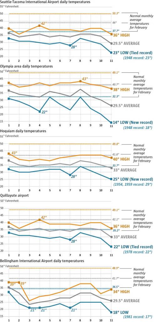
Several low-temperature records for Feb. 11 were broken or tied throughout Western Washington on Tuesday, meteorologist Dustin Guy said. Seattle-Tacoma International Airport tied its record set in 1948 as temperatures hit 23 degrees, while Olympia hit 14 degrees, breaking its previous record of 18 degrees set in 1948.
Hoquiam dipped to 25 degrees, beating its previous record of 29 degrees set in 1954.