Editor’s note: This story was originally set to run Saturday, but due to some internet server issues and really sketchy broadband in the mountains of California, here it is. Part III will run later this week.
By David Haerle
The Daily World
How crazy is it out there?
• You need a reservation to get into Yosemite National Park.
• After driving almost 1,200 miles — so far — and through umpteen national forests and past scores of state parks, I have seen one — just one — campground that did not have a “full” sign on it and that happened on Thursday, about 30 miles outside the northwest entrance to Yosemite.
• We all should have purchased stock in RV manufacturing companies. It may not be too late, based on my observations.
• The John Muir Trail maybe should be renamed the John Muir Scenic Pandemic Highway for the time being. There are that many backpackers in the High Sierra.
Now let me put some of that in perspective.
I worked in the high country of Yosemite for five summers during the late ‘70s and early ‘80s — three summers at a place called May Lake High Sierra Camp (elev. 9,270 feet) and two more at White Wolf Lodge (8,000 feet). This trip was largely planned to see what it was like there when I knew every campground, lodging facility, store, restaurant and all other services normally scattered along the Tioga Road would be closed, and entry to the park would be limited to those who made reservations online — which I did more than a month ago, but it still came back to bite me in the butt — sort of.
So, knowing I couldn’t stay in the park I searched for the next best thing — something close and in the mountains.
Problem is, if you approach Yosemite from the west (i.e. the I-5 corridor), there are two issues — the Central Valley heat and expensive lodging outside the park due to the hotels, lodges and motels with summer price points based on Bay Area incomes. Because it’s the fastest route from there to a park that averages 4 million visitors per year — the lion’s share in the summer months when the high country (which encompasses about 90 percent of the park) is open.
So I decided to approach the park from the east, the entrance closest to the heart of the high country. That meant a wonderful drive down the very scenic Highway 395, which I picked up in Carson City, Nev., to the little alpine hamlet of June Lake — possibly the most charming town and best kept secret of the Sierra. It’s a very offbeat, kind of a hippie town tucked next to two alpine lakes at 7,654 feet. Unlike the massive resorts at Tahoe to the north and Mammoth Lakes to the south, it’s very quiet with a very mellow vibe and a wonderful six-block “downtown” area. The view west from town is of an 11,000-foot wall of colorful granite monoliths aptly named Rainbow Ridge.
I could go on and on, but just Google it if you’re interested.
Back to Yosemite, literally and figuratively.
My friend, Boyce, who I met up with in Tahoe, joined me for the first couple of nights in June Lake. Our first venture into the park from base camp was Tuesday, the day I had my day-use reservation, which entitled me to seven days of in-and-out access to the park.
There was no one manning the east gate last Tuesday, so we zipped right into the park. We only made it about 10 miles in to Tuolumne Meadows, my late father’s favorite place in the world, before high tailing it out of there with an impending summer thunderstorm approaching. (We watched that spectacular show from the comfort of our second-story loft in June Lake, thankfully).
As we didn’t venture off the Tioga Road, my only real impression was how every major trail head out of this High Sierra hub — where the John Muir Trail and Pacific Crest Trail merge for a piece — was overflowing with cars. In my five summers working up there, I never saw anything like it.
We headed back to the park on Wednesday in two cars, as Boyce planned to drive through the park on his way back to his home in Elk Grove, Calif. (just south of Sacramento).
But when we got to the entry gate, there was a backup of cars hundreds of yards long. After 15 minutes of crawling toward the entry gate, a ranger started walking down the line. When he reached me, I showed him my reservation from the day before and he said to stay in line to pay my entry fee. But when he made it to Boyce’s car behind me, he wouldn’t let him proceed — even though he was a home-bound California resident. The ranger told him that “nobody can even drive through without a reservation.” Since the line was at a dead stop, I got out of my car and we said our good-byes. He made a U-turn and headed down the mountain and then north toward the Sonora Pass.
I had a chat with another ranger as I got closer to the gate, and she told me they have been turning away hundreds of cars this summer with only 3,900 reservations being allotted each day. That may sound like a lot, but only 1,900 go to day-use visitors like me. The rest go to people staying at the open lodges and campgrounds way down in Yosemite Valley and backpackers with valid back-country permits.
With best-laid plans gone awry, I improvised and headed to a little-known trail head tucked in the corner of the parking lot of what is usually Tuolumne Meadows Lodge, which would normally be bustling with about 300 guest this time of year. This summer it resembles a small ghost town among the towering pines and massive granite boulders.
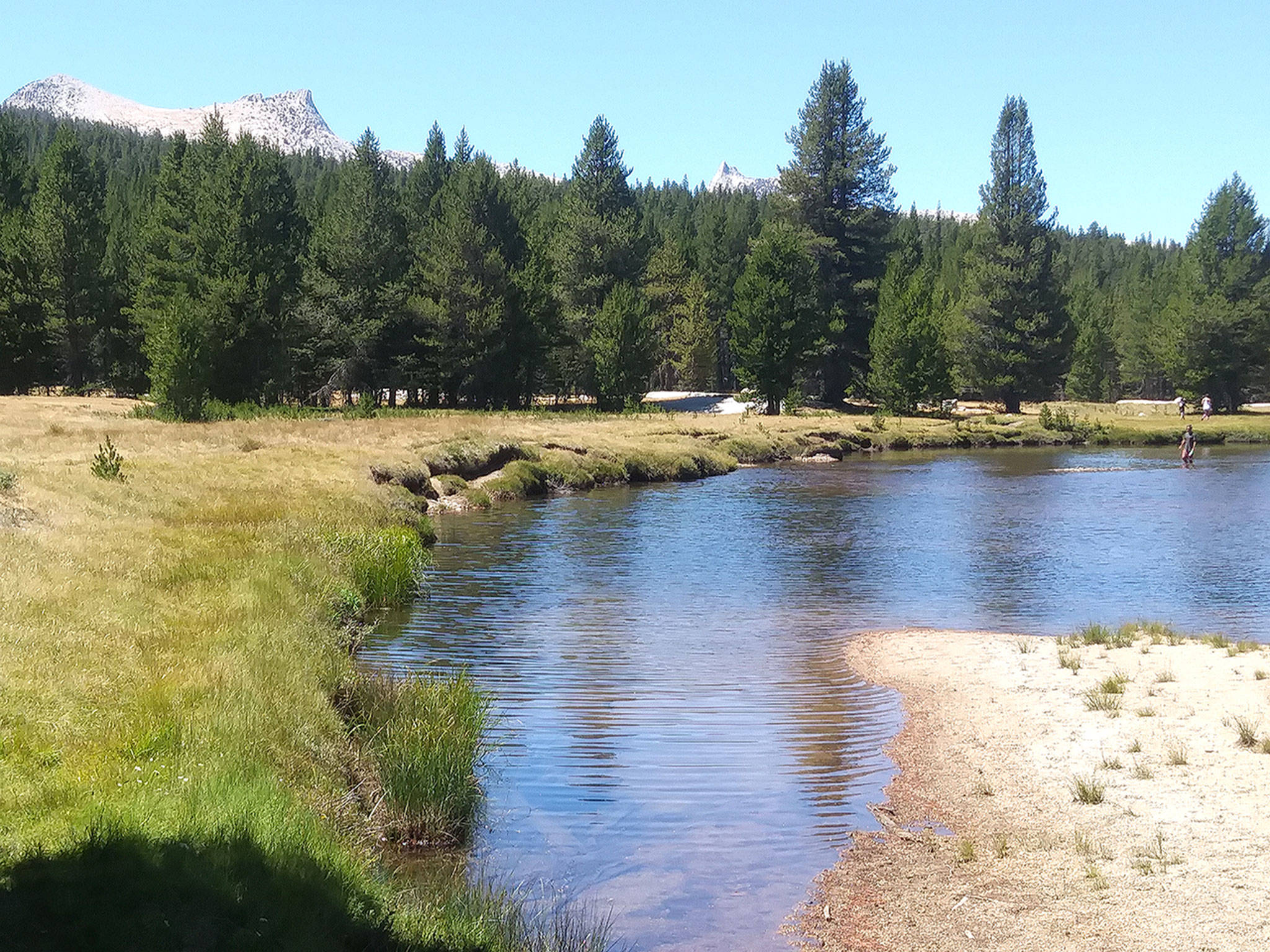
I took a hike past the Dana Fork and up to the Lyell Fork — the two headwaters of the Tuolumne River, where I found a secluded sandy beach along the river with a great swimming hole to my right and to my left a hundred-foot stretch of calm, crystal clear river in which I saw numerous rainbow trout as I walked by.
It was a warm day, so my first order of business was to test the waters. I waded into the glacier-fed stream up to my thighs, when I realized that there was no way I was going into this water any higher than my knees — if you get my gist. And since all the fish in that frigid water collectively decided they didn’t want to join me on the bank that day, I basically had a glorified picnic at the base of Unicorn and Cathedral peaks, two of my favorite mountains in the park and I climbed to the tip-top of both back in my youth. This day I just looked on in awe.
As part of that hike was along the John Muir Trail, I shared the route with numerous backpackers and had some nice socially distanced and brief conversations along the way. Most I talked to were doing the entire John Muir Trail, which stretches from Mount Whitney to Yosemite Valley (211 miles).
But one group that passed me quickly got my attention. It was a group of about 10, all with top-shelf — and light — backpacking gear. They were loudly talking about Wall Street stuff, which I found a bit sacrilegious for these parts, but I just rolled my eyes as they passed. Then, about a hundred yards up the trail, I heard the familiar clip-clop of a mule train, so I pulled off the trail. As the two wranglers with their mules in tow passed, I asked them where they were headed. They said they were following that group of hikers I had just passed with all their tents, food and gear on the backs of those beasts of burden. Also among the gear — a fully operational, back-country mess tent. Well, I guess that’s how the One Percenters are vacationing this summer.
Thursday was my final venture in and through the park. My intention was to visit White Wolf, where I worked for two summers. Unlike May Lake, which is accessible only by foot or horseback, you can drive right up to White Wolf, which, in a normal year has a lodge and restaurant that serves 50 guests. Nearby is a beautiful campground with 75 sites along a mountain stream that runs through it on its way to the Tuolumne canyon. But the road in was closed, which surprised me because there are two major trial heads there, so instead I headed to the one corner of the park I had never visited — despite driving by it scores of times — the Hetch Hetchy Valley.
Hetch Hetchy rivaled Yosemite Valley until 1938, when the The O’Shaughnessy Dam was completed. Today the 117-billion-gallon reservoir supplies drinking water to 2.4 million Bay Area residents (There’s the reason San Francisco’s tap water tastes so good.) and hydro-electric power generated by two plants downstream. The drive there was an adventure in itself as the road begins just outside the park and first goes over a rather bumpy National Forest road for 10 miles until you re-enter the park, where the quality of the road gets better but narrows significantly as you wind along the towering canyon wall. It’s quite hairy at points. I took a walk across the dam, snapped some photos and said goodbye to Yosemite.
I wrote this from my hotel room in Buck Meadows, Calif. — 30 miles outside the northwest entrance. It’s tucked in the pines of Gold Country at about 4,000 feet, where it was a balmy 91 degrees (72 in my air-conditioned room). I departed early in the morning to traverse the Central Valley, where temperatures reached 110 the day I drove through (I am not kidding). My destination was the San Francisco Bay Area, where I was to golf and spend a night in Sonoma County with a college buddy who was also my best man. Then for my final night, the plan was to try to self isolate as best I can in my hometown of San Francisco. But then the massive heat wave and the weirdest weather I have ever seen in the Bay Area. I will let you know how that all worked out in my final installment.
Dave Haerle is the city editor at The Daily World. Reach him at dhaerle@thedailyworld.com.

The view from the rooftop deck at my June Lake, Calif., vacation rental. I apologize for my sardonic sense of humor in this shot.

Because there is no campgrounds open in Yosemite’s high country, recreational vehicles are few and far between. That means they are not clogging the curvy, mountainous Tioga Road. Four bears have been killed by speeding cars so far this summer, so these signs are all over the park. (Photo by Boyce Jeffries)
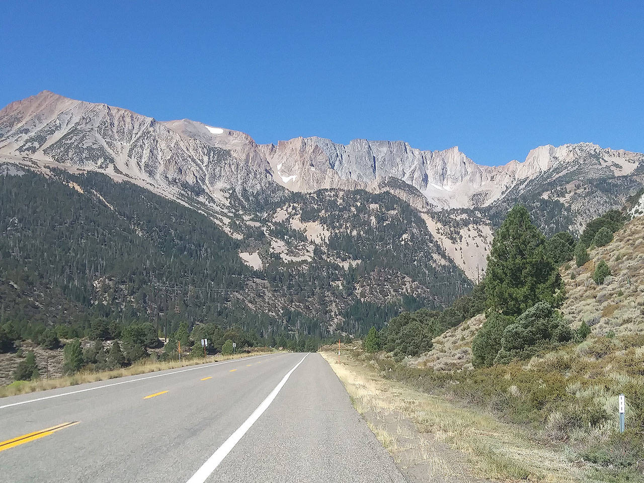
When you drive up the Tioga Road to enter Yosemite National Park from the east, you are greeted by this wall reminiscent of something out of “Game of Thrones.” I doubt fire-breathing dragons would have any luck against these sheer wall of granite that reach 11,000 feet in elevation.
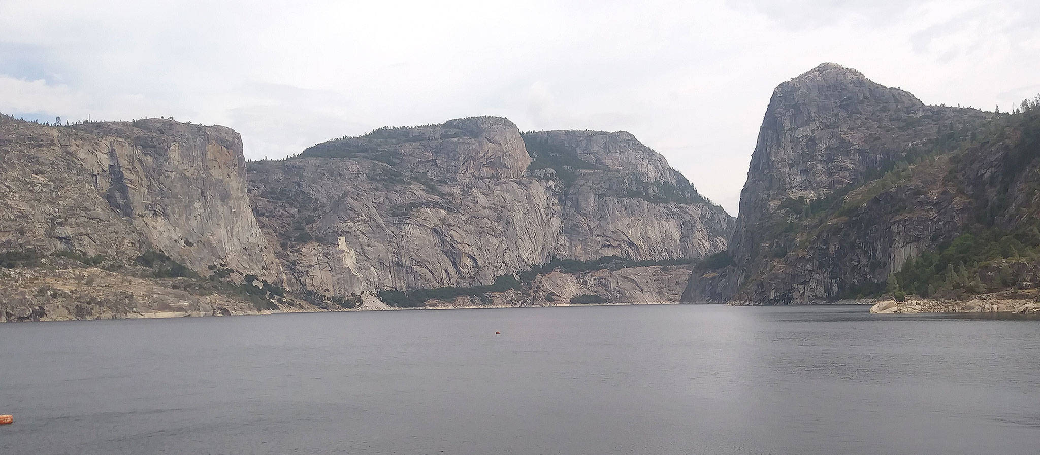
The Hetch Hetchy Valley, tucked in the northwest corner of Yosemite National Park, once rivaled the famed Yosemite Valley for sheer beauty and 3,000-foot granite walls until it was dammed and flooded in 1938 as a water supply for the city of San Francisco, which is more than 150 miles to the west.