Dam could imperil one of WA’s last unobstructed rivers
Published 1:30 am Friday, March 27, 2026
Growing up in the 1970s Montesano on the Chehalis River, Quinault tribal member Ken Corwin waited with anticipation for each year’s fall run of Chinook salmon.
“The Chehalis had lots of fish back then,” says Corwin. “I remember watching one Chinook after another jumping in the river. I don’t see that much anymore.”
Corwin’s father and grandfather were fishermen, and when he was old enough Corwin started going out in his own boat. This was after the height of the period known as the “salmon wars,” a period in the 1960s and ’70s when tribal members engaged in civil disobedience by fishing their traditional waterways in defiance of exclusive state laws.
Even so, Corwin encountered abuse from non-tribal fishermen who saw Indigenous fishing as a threat.
“I’ve experienced all kinds of things,” says Corwin. “I’ve been cussed at and shot at. The last several years have calmed down a lot in that respect.”
A 1974 court case that came to be known as the Boldt Decision sided with Washington tribes, holding that they have a treaty-protected right to half the fish caught in their “usual and accustomed” waters.
For the Quinault Nation, this included the Chehalis River.
Now, though, tribal members’ ability to exercise this right has come under threat again.
A host of factors from deforestation to climate change have hurt salmon in the Chehalis, to the point that some runs might never recover.
There’s one thing they haven’t had to contend with: dams. But that could change.
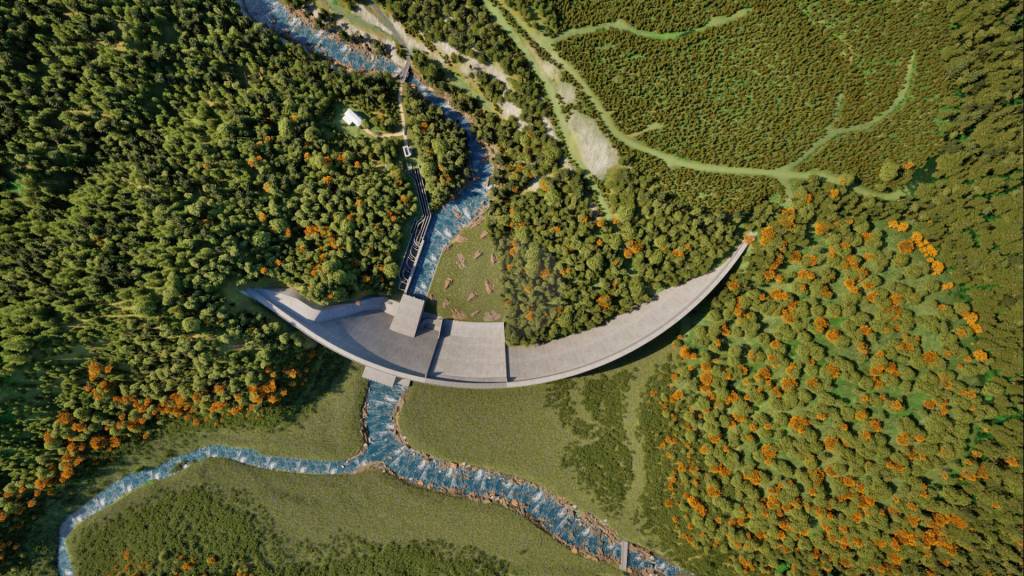
A “flow-through” dam on the Chehalis just south of Pe Ell would create an artificial reservoir during major flooding events. Also known as perforated dams, flow-through dams are constructed solely for the purpose of flood control. Unlike reservoir dams, the spillway (opening) is built at the same height as the riverbed level, allowing the river to continue its natural flow in normal conditions and allowing fish to pass through except during floods, when openings seal shut.
According to the local Flood Control Zone District, the structure “will reduce the extent of flood damage to people, homes, businesses, farms and transportation.”
The structure won’t generate electricity, and it won’t permanently obstruct the whole river in the way a traditional dam would. Still, it would inevitably change currents and silt deposit patterns, altering habitat for salmon and other wildlife.
“Anything that uses the river will be affected,” says Corwin. “Salmon, birds, humans, all are going to see an impact.”
Giant conveyor belt
The Chehalis is one of the West Coast’s last free-flowing rivers, running unimpeded from tributaries in the Cascade Range foothills and southern Olympic Mountains to an estuary on Grays Harbor.
In contrast to most rivers in the region, salmon in the Chehalis can reach even the upper tributaries without having to bypass dams.
“That’s critical,” says Liz Gilliam, a geomorphologist for Pacific Rivers. “It allows salmon to reach the cool upper headwaters where they survive the hottest, most lethal times of year.”
The Chehalis River Basin Flood Reduction Project, as the plan that includes the proposed dam is officially called, wouldn’t permanently blockade the river. Gaps in the dam’s retention wall would allow salmon to pass through, with gates closing the openings only during large flood events. Water would then be held in an artificial reservoir and released gradually over days or weeks.
According to the project website, “fish will be free to swim upstream and downstream past the facility” most of the time.
Even so, critics worry the wall and reservoir will alter the ecosystem in ways that affect salmon.
“A river is like a conveyor belt moving sediment, woody debris and even large rocks downstream,” says Gilliam. “I’ve studied dams throughout the region, and they all create bottlenecks that restrict what the current carries. You end up with a downstream channel starved of sediment.”
Releasing water from behind the retention wall, where it would typically be held for around 30 days after a major flood, would have its own downstream impact.
“Water will heat up in the reservoir, affecting downstream temperatures when it’s released,” says Brian Stewart, Cascades to Olympics program manager for Conservation Northwest.
Construction impacts
Building the dam would require “dewatering” a section of river, work that can be done only during a limited window in summer.
Though it’s a precaution to minimize disruptions for migrating salmon, this short annual window means finishing the dam will likely take years, with species that remain in the river affected in the meantime.
“River flow is already low during the time of year when construction would take place,” says Gilliam. “There are organisms that persist in gaps in gravel over the summer that will be affected by dewatering. And it’s going to be ongoing for a long time.”
Impacts on the river ecosystem will ultimately affect not just salmon, but species in the food chain all the way up the Salish Sea’s Southern Resident orcas, which feed almost exclusively on Chinook.
“Southern Residents depend on Chinook salmon,” says Shari Tarantino, executive director of the Orca Conservancy. “Even temporary construction-phase impacts that reduce salmon survival or delay migration would further undermine efforts to recover this critically endangered population.”
‘Wake-up call’ in a floodplain
Outside the small town of Pe Ell, the Chehalis River flows clear and cold through a channel thick with plant life. Lichens hang from branches of Douglas firs and bigleaf maples growing along the banks. On a rock at the water’s edge, an American dipper bobs before diving beneath the waves to hunt aquatic insects.
Focus only on the riverbank, and it would be possible to imagine you’re seeing the Chehalis as it looked prior to colonization.
But just beyond the ravine a narrow band of forest gives way to agricultural fields. It’s a reminder that while the Chehalis may be free flowing, the landscape it passes through is no wilderness.
“Mostly it’s tree farms,” says Stewart. “But increasingly, those are being replaced with shopping centers and housing developments.”
Twenty-four miles downstream, the river skirts the Chehalis-Centralia Airport and a Walmart Supercenter.
It was here, during a major storm in 2007, that the Chehalis surged over its banks, leading to flash floods that damaged 3,000 homes and submerged nearby Interstate 5 under 14 feet of water.
“That flood was a wakeup call for communities along the river,” says Lee First of Twin Harbors Waterkeeper.
The 2007 disaster set in motion a long process that by 2020 led to the local Flood Control District releasing the first iteration of a planned flow-through dam upstream from Pe Ell. That initial version was abandoned after the Confederated Tribes of the Chehalis Reservation raised concerns about cultural sites, prompting then-Gov. Jay Inslee to call for alternatives.
Last fall, the district released a new plan. It involves a dam that attempts to avoid important cultural sites, but which is even bigger than the original.
The Flood Control District says the structure will “protect up to 1,800 people from displacement” and “decrease flood damage to structures by 50-72 percent.”
The Quinault Nation, Confederated Tribes of the Chehalis and environmental groups still have concerns and say there are other ways to address flooding. These might include a combination of levees, moving homes out of the flood plain and redirecting the river’s flow.
“There’s no silver bullet that will stop the dynamics of a river like the Chehalis,” says Stewart. “We have to find a way to live with floods so they don’t wipe everyone out.”
Flood damage along the Chehalis is a result of decades of development in the river’s floodplain, something neither the proposed dam nor most alternatives can completely mitigate.
If the dam is built, some opponents worry it will lead to a false sense of security.
“For developers, it would be like a free ticket to continue building in the floodplain,” says First. “It’s a vicious cycle.”
Edge of extinction
On the hills above Pe Ell, spindly Douglas firs grow up to the edge of a recent clear-cut, a sign of how human actions have reshaped the watershed over the last century. Development has degraded salmon habitat even without a dam.
“There are so many things returning salmon have to get through to survive, it’s mind-boggling,” says Corwin. “From pollution to higher water temperatures due to climate change to giant ocean trawlers catching entire schools of fish. It’s amazing any of them make it.”
Decades ago, it was possible to make a good living fishing on the Chehalis River.
“Today you’re kind of lucky if you break even,” says Corwin.
Still, for the 50 or so Quinault tribal members who fish on the Chehalis, it’s an important cultural activity that brings people together.
“I would say, no, you can’t survive on fishing like you used to,” says Corwin. “But it remains a fishery we very much depend on.”
Corwin used to fish for multiple commercially valuable salmon species, but now catches mainly coho. There are still Chinook and steelhead in the river, but these might not last.
The situation is dire for spring Chinook, a candidate for Endangered Species Act listing. According to Washington’s Department of Fish and Wildlife, this imperiled run could go extinct in 60 years without help.
Salmon advocates worry a flow-through dam could push spring Chinook in the Chehalis over the edge into extinction. It’s one of the more severe potential impacts for life on an already embattled river.
“Unfortunately, the trend for salmon in the Chehalis has been downward,” says Corwin. “It’s only getting worse.”