National Weather Service issues red-flag weather warning for western Washington
Published 2:30 pm Monday, September 7, 2020


The National Weather Service has issued a red-flag warning as expected blustery winds and hot, dry conditions have increased the risk of fires in Western Washington, including the Twin Harbors this week.
The weather service says easterly winds are expected across western Washington from late Monday through Tuesday and, combined with temperatures expected in the high 80s to low 90s for the week, create a “heat risk and critical fire weather conditions.”
That information holds true for Grays Harbor and Pacific counties as well, where high winds are expected early in the week with high temperatures peaking on Wednesday and Thursday.
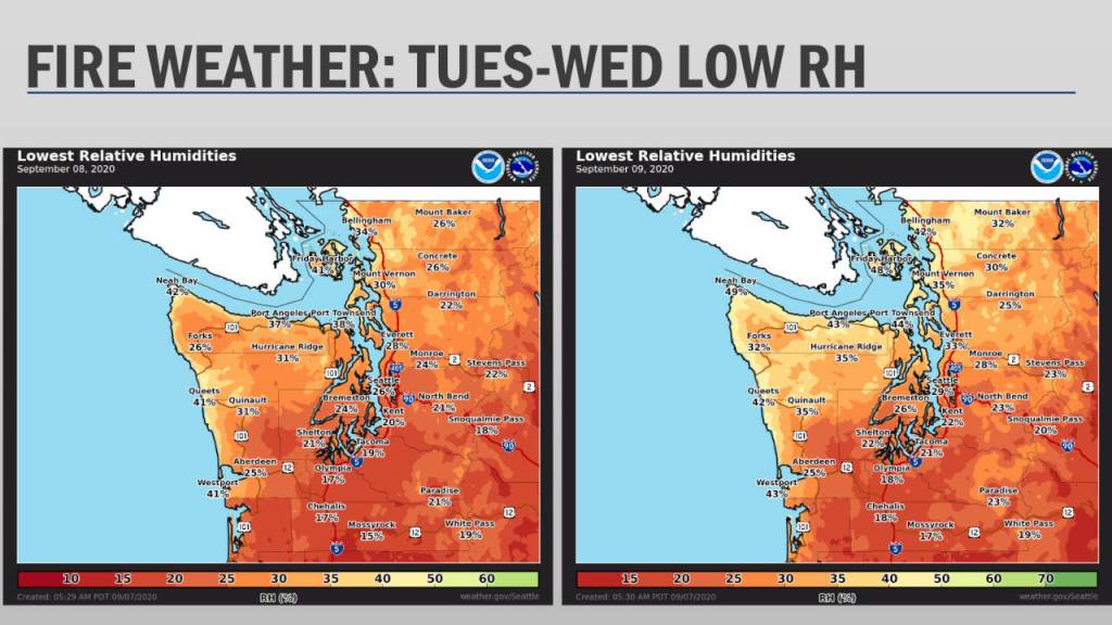
“In terms of critical fire conditions for the area, those are going to peak (Monday night) and into Tuesday where the winds are going to be the strongest,” National Weather Service Forecaster Carly Kovacik said. “We are going to see the winds shift to the east (Monday evening) and continue into Tuesday morning before gradually subsiding in the days after that.”
Kovacik stated that while the weather service predicts the winds to calm on Wednesday and through the rest of the week, the hot and dry conditions still pose a greater fire risk.
“We are still expecting critical fire conditions to continue for the area on Wednesday and Thursday, but that is going to be more for dry conditions and warm temperatures,” she said. “So though the winds won’t be quite as strong, we are still going to have very dry conditions and warm temperatures.”
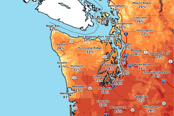
According to the service, northerly breezes will shift to easterly late Monday and into Tuesday and are forecasted for 15-25 miles per hour in the Twin Harbors.
Historically, easterly winds in the area tend to be stronger with lower humidity than the typical northern winds. The easterly winds are expected to lighten by Wednesday.
Temperatures are expected to peak on Wednesday and Thursday, with a forecast of 87 degrees in Hoquiam and 91 degrees in Montesano on Wednesday.
Kovacik said that while easterly winds may still be present on Wednesday and Thursday, it will likely be on a limited basis.
“(They) will still be coming out of the east and may be a little breezy at times,” she said. “But we’re looking for those strongest winds to be (Monday night) and Tuesday morning.”
The Washington State Department of Natural Resources classified both Grays Harbor and Pacific counties Monday as subject to moderate wildfire risk.
For more information, visit the National Weather Service website for Washington state at weather.gov/sew/.