Design phase underway for Westport vertical tsunami evacuation platform
Published 3:30 pm Monday, September 28, 2020


The City of Westport has been working toward installation of a vertical tsunami evacuation platform for many years, and is now closer than ever to the goal.
“Four years ago, Ocosta School District became the first entity in North America to construct a vertical tsunami evacuation structure,” said Dr. Harry Carthum, chairman of the city committee driving the project. “The good news is now we will, with certainty, become the first city in North America to protect not only our school children but all our residents and all our visitors, we have gotten that far along.”
Carthum and other members of the committee joined Westport Mayor Rob Bearden, city Public Works Director Kevin Goodrich, and tsunami platform planners and designers to update the committee’s progress for about 50 participants via Zoom Thursday.
In 2009, FEMA published its guide for vertical evacuation and about the same time the University of Washington and state Department of Emergency Management commissioned a “safe havens” study. That study identified four sites in Westport that would be appropriate for evacuation structures.
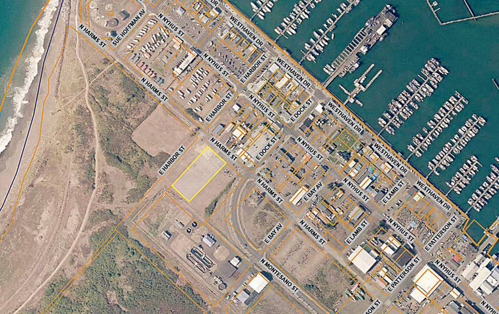
The largest of the four is the one the committee is focused on now, in the marina district, said Carthum.
“The original concept for the dock area was to build a parking structure on Port (of Grays Harbor) property adjoining the public washrooms,” said Carthum. “For a couple of reasons, that hasn’t worked out; the property was not available and the cost of putting up a parking structure was prohibitive.”
That lead to the current design, “a tower structure on city property just off Harms Avenue,” said Carthum. “It will still be very convenient to the dock area and the washrooms and would provide shelter and safety for the maximum number of people in Westport.”
The goal is to complete that structure, or at least get it under construction, then move on to build three more: “One near City Hall (Montesano Street and West Sprague Avenue), one in the area of Ocean Avenue and Forrest, near the lighthouse I suspect, and somewhere at (West) Newell (Avenue) and Forrest,” said Carthum. “Studies show those sites would be available to almost everybody who lives or visits within the city limits of Westport.”
The city is working with a FEMA and state Emergency Management advanced assistance grant to develop the design of the platform, said Goodrich. The amount of the project to get the tower ready for construction is $114,000; the grant is a little more than $103,000, leaving the remainder to the city to cover.”
“That was a big deal (to get the assistance grant),” said Goodrich. “It took almost two and a half years to get the grant applied for and then wait for FEMA to give us a yes or no. Thankfully, they gave us a yes.”
A finalized design will allow the city to apply for a construction grant from FEMA, said Goodrich, to build the structure.
The structure will cost between $1 million and $1.5 million to construct, said Carthum.
“Financing is going to be a challenge,” said Goodrich. “I’m hoping we can put the right kind of proposal where FEMA will step up to the plate and put some money on the table.”
A FEMA grant requires a 10% city match, regardless of the finished cost of the project, said Goodrich.
“Whether we fund through other donations, bonds, line items, the state Legislature, all those things will come together,” said Goodrich. “I feel like we have a team in place that will put the best project forward and give us the best chance for success.”
Community cooperation is key to building such a structure.
“The community really took a historic step when it supported the Ocosta structure,” said Dr. Paula Ackerlund, a member of the committee and former Superintendent of the Ocosta School District who spearheaded the effort for the Ocosta structure atop the school gym. She said she is confident the next step in building the Westport structure “would be supported just as strongly, and I feel very privileged to be a part of that.”
The structure
Ron Easterday, an architect from Rice Fergus Miller in Bremerton, said the current FEMA grant will pay for a conceptual design, documentation of a cost-benefit analysis and other requirements to apply for a FEMA construction grant. Grant applications are due in December.
“The conceptual design is a concept plan, a fully-developed, site-specific rendering,” said Easterday. “There will be a cost estimate for construction, a project budget that includes the conception cost and other related costs, design fees, all the other costs associated with the project to get it built.”
The structure will have an estimated capacity of 1,000 people, which, per FEMA, requires 10,000 square feet of refuge area, 10 square feet per person. In reality, such a structure could hold up to 2,000 people if needed. The multi-tiered platform made of concrete and steel able to withstand several surges of waves of up to 20 feet for the duration of the tsunami event would stand up to 50 feet high in total.
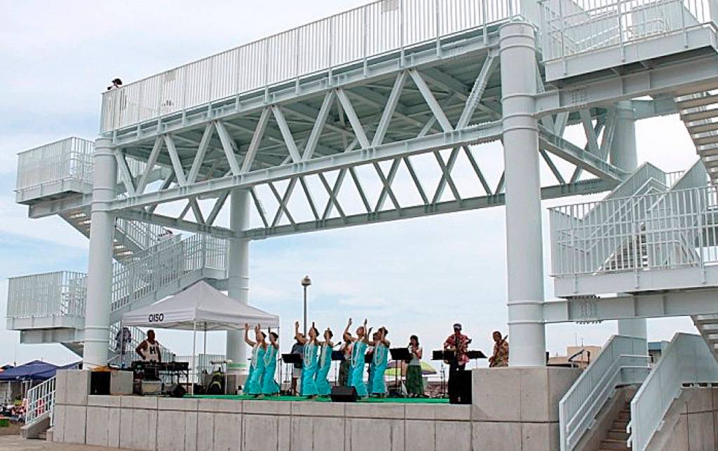
The structure could incorporate features that would make it more than an emergency evacuation asset. One of Thursday’s presenters, Roger Long, said the prominent feature could integrate some other uses and become “kind of a front porch” for the community, not just a reminder of the threat of a tsunami.
One example was shown of a platform in Japan, which on its lower level had a covered stage.
Carthum said the committee is open to private-public partnerships looking at other uses for the structure as a way to defray the cost of the structure.
“We will try to keep looking at ways to make this some sort of event structure underneath this thing,” said Carthum. “If we have to look for funding to extend the bottom level or cover it in some way we’ll do this.” It was said at the presentation that the cost of such modifications would not be covered by FEMA grant money and must come from another source.
“The main thing right now is to get this built for the safety of our citizens and our visitors,” said Carthum.