National Weather Service: Odds tilt in favor of winter La Niña
Published 1:30 am Tuesday, August 19, 2025
The National Weather Service issued a La Niña watch, raising hopes the coming winter will bust up stubborn drought conditions in the Northwest.
The weather service’s Climate Prediction Center reported the odds slightly favor a La Niña forming by November and sticking around for December and January.
A La Niña increases expectations that snow will pile up in the mountains and melt into rivers. La Niñas sometimes fizzle. A La Niña formed last winter, but the Washington snowpack was disappointing. Still, it’s the main guide for seasonal forecasts.
“It’s not a sure thing, but it does make me a little more optimistic about winter and that we could see more precipitation and start drought recovery,” Washington State Assistant Climatologist Karin Bumbaco said.
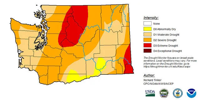
Most of Washington, Oregon and Idaho are in some level of drought. The region did get doused this past weekend. The rain cooled off fish and dampened wildfires, but it won’t be enough to erase moisture deficits that have been building up for months, Bumbaco said.
April through July was the third driest such four-month period on record in Washington, according to the National Centers for Environmental Information. Records date back to 1895.
Prolonged dry spells make falling into drought easier and getting out of one harder, Natural Resources Conservation Service hydrologist Matt Warbritton said.
“There’s been incredibly poor precipitation conditions throughout this summer and really since about mid-spring,” he said.
Cooler-than-normal sea-surface temperatures along the equator in the Pacific Ocean cause a La Niña. The warm seas interact with the atmosphere, blowing wetter and colder weather over the northern tier of the U.S. and drier and warmer weather over the southern tier.
Sea-surface temperatures are currently normal and expected to stay that way for the rest of the summer and into the fall.
By late fall, the odds shift to favor a La Niña, though the chances are still less than 60%. It’s almost as likely the seas will stay neutral. The chances an El Niño will form are small, according to forecasters. An El Niño typically means warmer and drier winters in the Northwest, causing or worsening droughts.
To make its prediction, the climate center evaluated 24 models that try to forecast ocean temperatures. To an unusual degree, the models agree the upcoming La Niña, if it forms, will be weak and short-lived.
Some 95% of Washington is in drought, the U.S. Drought Monitor reported Aug. 14. The worst hit areas are parts of Asotin, Garfield and Whitman counties in southeast Washington, and Chelan and Okanogan counties in north-central Washington.
Drought covers 86% of Idaho, with the driest areas in the Panhandle and in parts of Twin Falls and Cassia counties in Southern Idaho.
Some 56% of Oregon and 40% of California are in drought. Drought covers 65% of the Western 11 states.