Site Logo

Updated forecast on two storms expected tonight and Monday through Tuesday

Published 4:15 pm Sunday, February 10, 2019

(National Weather Service) The blue shaded zones shows areas included in the winter storm watch for midday Monday through Tuesday night. Areas south of the yellow line are where warm and cold air could mix, causing a potentially dangerous mix of snow, rain and sleet. The red line circles areas that could see some of the most snow with 9 to 12 inches.
1/2

(National Weather Service) The blue shaded zones shows areas included in the winter storm watch for midday Monday through Tuesday night. Areas south of the yellow line are where warm and cold air could mix, causing a potentially dangerous mix of snow, rain and sleet. The red line circles areas that could see some of the most snow with 9 to 12 inches.

(National Weather Service) The blue shaded zones shows areas included in the winter storm watch for midday Monday through Tuesday night. Areas south of the yellow line are where warm and cold air could mix, causing a potentially dangerous mix of snow, rain and sleet. The red line circles areas that could see some of the most snow with 9 to 12 inches.
Updated forecast on two storms expected tonight and Monday through Tuesday

Two storms will move through western Washington today through tonight, and Monday through Tuesday, according to the National Weather Service in Seattle.

In the update, it says the second storm will be stronger, with bigger impacts on the region. The first storm is expected to produce 1 to 4 inches of snow in lowland areas, with snow falling along the coast midday Sunday and the interior in late afternoon. Heaviest snow will be late Sunday evening in the interior. There’s a winter weather advisory through tonight.

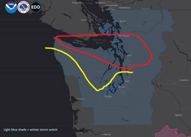
The second storm is expected to produce 5 to 8 inches of snow in the lowlands. There’s a winter storm watch for Monday through Tuesday in all areas of western Washington except the central coast. Areas east of Aberdeen are not included in the winter storm watch, according to a National Weather Service graphic.