Preventing crashes, protecting wildlife is goal of new WA plan
Published 1:30 am Thursday, July 10, 2025
Two Washington state agencies are looking to improve corridors for wildlife while cutting down on traffic risks for motorists and animals.
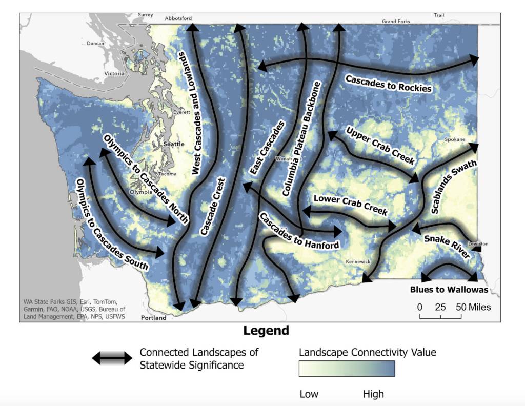
The Department of Fish and Wildlife and the Department of Transportation released their Habitat Connectivity Action Plan last week. The strategic plan presents a statewide map of Washington’s roadways and habitats, with the goal of identifying the best places to protect and restore wildlife movement.
The full plan is available at the Washington Department of Fish and Wildlife website.
Interactive maps and other planning resources are available at ArcGIS online.
The plan gives Washington a shared map and tools so local planners, land owners, tribal governments and state and federal agencies can work together on the issue, said Julia Michalak, priority habitats and species manager with the Department of Fish and Wildlife.
“Wildlife doesn’t stop at county lines or property fences,” she said.
Developed in collaboration with local and tribal governments, conservation groups, and technical experts, the plan includes regional strategies tailored to the specific needs of different parts of the state.
Local governments are encouraged to use the data in the plan for land-use planning, zoning, and guiding conservation efforts.
The data will help the Department of Transportation plan safer roads that work better for people and wildlife, said Glen Kalisz, a habitat connectivity biologist with the agency.
“This kind of statewide coordination allows us to identify where to focus our investments, design more effective crossings, and support healthy ecosystems across Washington,” Kalisz said.
In the plan, the Department of Fish and Wildlife and the Department of Transportation outlined 13 landscapes that are essential for connecting core ecological areas.
The plan also identified 38 sections of state highways where actions like building wildlife crossings, installing fencing, or retrofitting culverts could offer significant benefits.
For example, a two-mile section of U.S. Highway 2, west of Cashmere, was highlighted as a severe wildlife-related safety hazard due to a high number of vehicles hitting deer.
Between 2019 and 2023, there were 32 deer carcasses removed, 19 deer crash reports and five human injuries caused by wildlife-vehicle collisions in that stretch of road, according to the report.
The section of highway has a large-span bridge underpass conveying the Wenatchee River, which the plan says offered a strategic and cost-effective opportunity for targeted retrofits that could allow for safer movement of deer and other wildlife.
The report also noted a one-mile span of Interstate 90, west of Snoqualmie Pass between Keechelus and Kachess lakes. Here, I-90 bisects the Okanogan-Wenatchee National Forest and, due to the road’s extreme traffic volume, it is considered a major barrier to wildlife.
Improvements to that section of I-90 are included in the Snoqualmie Pass East Highway Widening Project, with four wildlife underpasses and wildlife exclusion fencing expected to be built in 2028 and 2029.
The Cascades Conservation Partnership and the I-90 Wildlife Bridges Coalition have been working since 2000 on various projects intended to reconnect Washington’s north and south Cascades by protecting and restoring habitat and establishing safe wildlife crossings under and over I-90.