Fry Creek Restoration approaching construction
Published 7:00 pm Tuesday, February 27, 2018


The Fry Creek Restoration Project is now in the final stage of design for its first building phase and could begin construction sometime next year now that the Aberdeen City Council has approved it.
Aberdeen City Engineer Kris Koski said the designs should be completed either in the last quarter of 2018 or the beginning of 2019, and that he hopes to begin construction in 2019. He noted that it will likely be the first of the Timberworks projects to actually see construction.
“The project is funded and in design, which is exciting since it’s the first Timberworks project to really break ground,” said Koski.
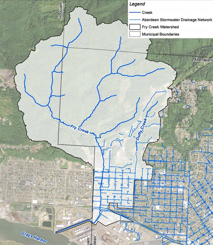
The Timberworks Master Plan is a regional effort to address flooding issues in Aberdeen and Hoquiam, and has identified a variety of subprojects, such as the North Shore Levee Project and Fry Creek, to address the problems.
Fry Creek, located just east of the boundary between Hoquiam and Aberdeen, has been a major source of flooding from Cherry Street south to Pacific Avenue, and a wide surrounding area. Whenever there is high rainfall, the five culverts running under these streets can become overloaded with water, causing runoff to spill out into the surrounding neighborhoods. Public Works Director Rick Sangder said one of the main issues they identified is that the culverts and parts of the stream are too narrow.
“The biggest problem with the creek is conveyance,” said Sangder. “The shrinking of the shorelines has definitely been a problem as well. But a lot of the culverts in our modeling were proven to not be adequate to carry flows downstream.”
Koski added that because many nearby storm drains lead back into Fry Creek, the flooding can spread to a wide area.
“Even if it’s not a huge amount of water, it doesn’t drain out of that area very fast,” said Koski. “If it does drain out and enter a storm drain, it leads right back to Fry Creek, so there’s nowhere for it to go.”
The project intends to expand the culverts and creek banks in order to remove flooding in many of the areas currently affected.
It has been in development since spring of 2016 and received construction funding ($2.215 million) through the Washington Coast Restoration Initiative in January’s state biennial capital budget. Aberdeen and Hoquiam staff have been working in partnership with the Maul Foster and Alongi consulting firm and KPFF Consulting Engineers on the project and have conducted multiple surveys on the creek’s geometry and water flow to understand how widening certain stretches of the creek would affect areas downstream.
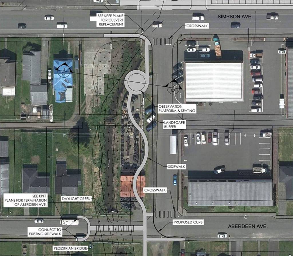
The first construction phase, which was approved by City Council at its Feb. 14 meeting, will focus on widening and improving the creek from Simpson down to Bay Avenue.
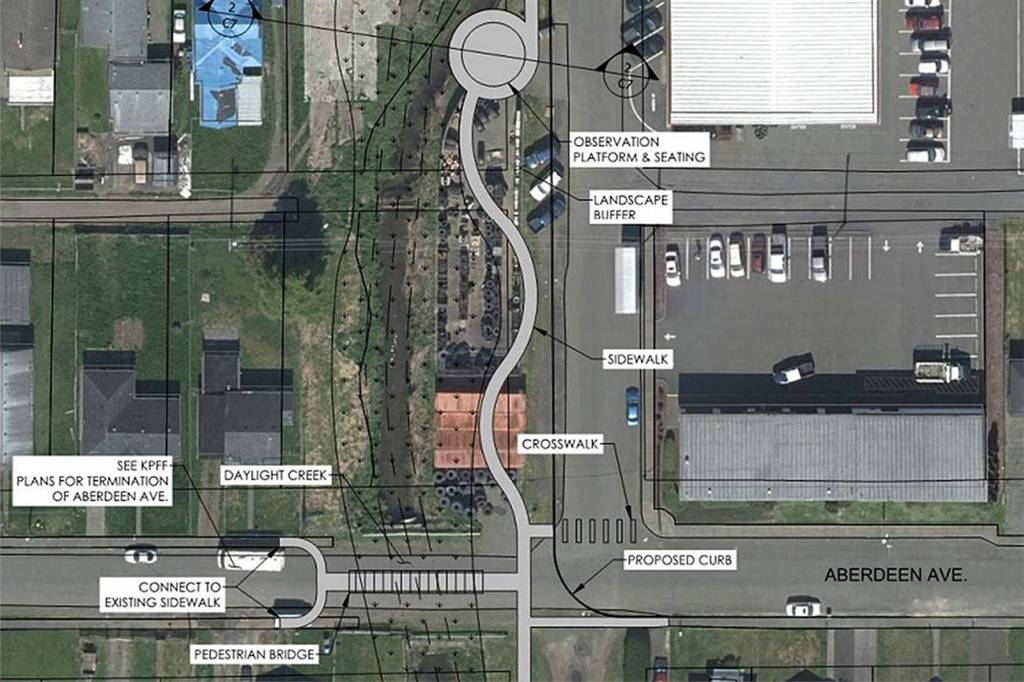
As shown in a preliminary design diagram, this would mean expanding the banks of the river to the edge of the dotted area, and installing new wider culverts, thus allowing for a greater flow of water. In addition, the city would remove the portion of Aberdeen Avenue where it crosses the creek to allow for greater flow there without a culvert, and then install a walking bridge over the creek.
At the moment, the diagrams also show there being a walking path and observation area following the creek between Simpson and Pacific avenues, where part of the Les Schwab Tire Center is currently located.
By doing this initial construction, the project’s reports show a significant reduction in flood potential on Myrtle Street, after flowing from the culvert at Aberdeen Avenue, and a moderate reduction of flooding on Cherry Street. Koski said this first stretch of construction was the only place they could expand the creek without creating increased flooding in other spots downstream.
“The option that makes the most sense for a first phase is to improve the Aberdeen and Pacific avenue crossings,” he said. “It’s the only option that reduces flooding in a serious way without flooding out somebody else.”
Koski and other project staff modeled the amount of flooding before and after improvements at each street crossing by analyzing how each improvement would affect overflowing during a 100-year flood (a flood so large it only has a 1 percent chance of occurring each year). Following the first phase of construction, the report shows that Myrtle Street would have its overflow reduced from 2.11 acre-feet to zero, while floods on Cherry Street would have approximately 20 percent overflow reduction.
Some of the construction builds pathways or expands the creek banks into back yards and properties, and Koski said they would need to acquire the land to build on it and have been in contact with owners.
Later steps in construction will include replacing the creek’s pump at Port Industrial Road, installing a new one at the train-crossing just north of it. Koski said it would allow the city to significantly increase the amount of water that is discharged through that culvert.
These aspects of the project were also discussed and modified by an advisory committee, which met twice in 2017. That group included members of Grays Harbor PUD, WDFW, Grays Harbor College Fisheries, Conservation District, property owner Kathi Hoder and the Port of Grays Harbor.