She comes and she goes, but when she appears, the remnants of a long ago Willapa Harbor shipwreck on the beach at North Cove never fails to fascinate and draw hundreds of visitors to explore her and to theorize on her origins.
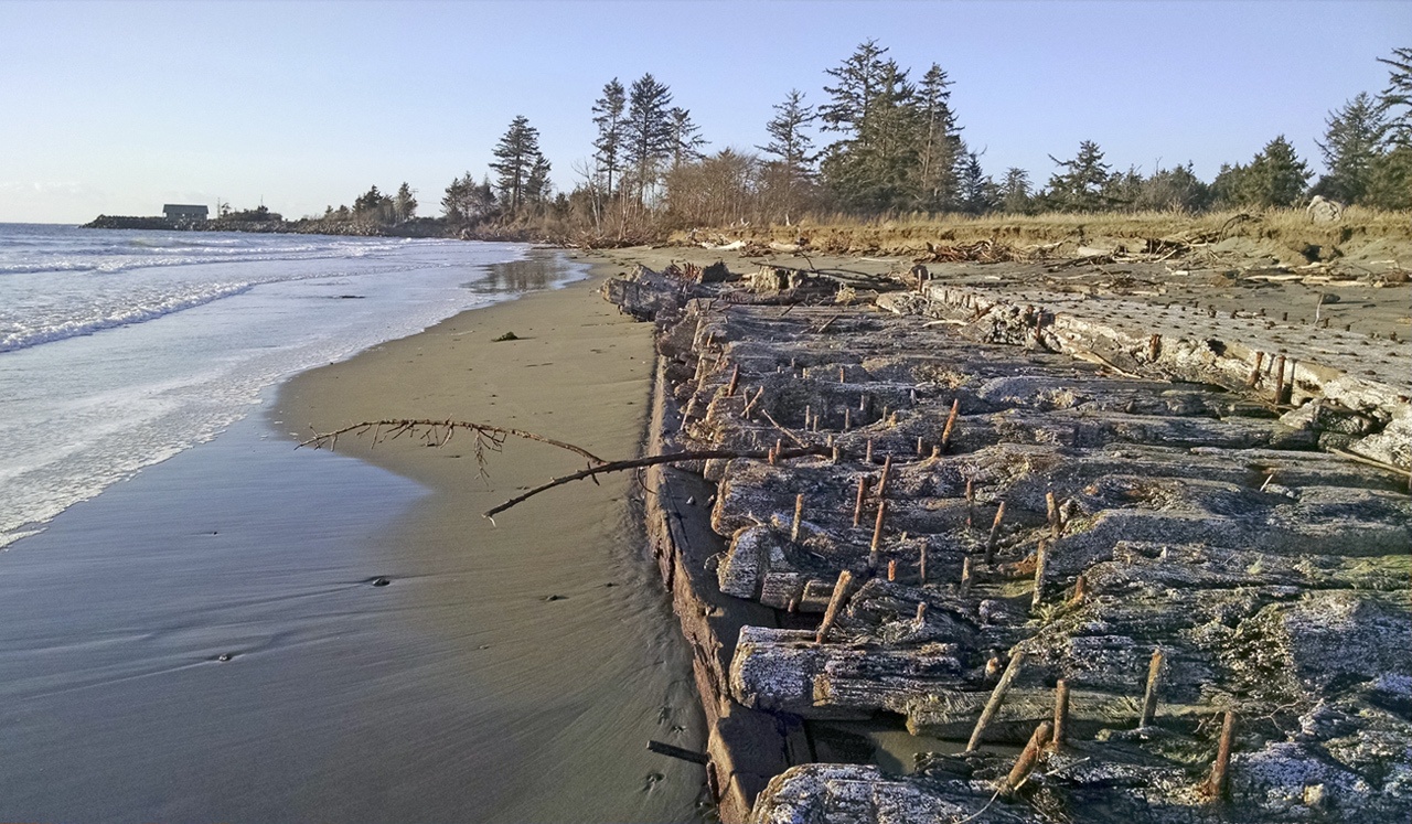
The approximately 125-foot-by-20-f00t. piece of what appears to be hull and/or deck timbers held together with large spikes first showed herself in late December 2009. Storm-tossed waves ate away huge chunks of the bank line just south of Warrenton Cannery Road, revealing a hint of what was to come.
By early February of the next year, the entire piece was revealed. Originally lying parallel to the shoreline, by mid-February, high tide wave action had eroded enough of the bank line behind the wreckage to allow backwash to float the mass so that it rotated 90 degrees, leaving its narrowest end facing into the waves.
About month after it was freed from the bank, the wreck ‘disappeared’ from the area— either covered with sand or afloat at sea. It revealed itself again in the spring of 2010 about 100 yards farther south down the beach toward the mouth of Willapa Harbor.
After a short time, once again, the shipwreck seemed to disappear until early December of that year, when it showed up near the western end of Washaway Beach, totally uncovered and visible in all its estimated 125-foot glory.
At least small parts of the shipwreck remained visible as it has repeated the process of drifting and beaching southward then around into the mouth of Willapa Bay and east along Washaway Beach to a spot west of Tumidanski Tongue at the end of Old Tokeland Road. There, wind-pushed sand partially covered the timbers.
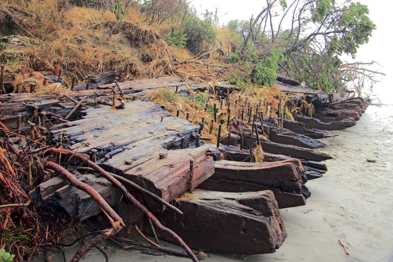
In mid-October of last year, with erosion slowing along the northern bank line of the bay, the complete piece of wreckage was again revealed. Since then, it has continued its eastward journey. By late November, it settled in south of the Tumidanski property, but still well north of Jacobson’s Jetty, where it can still be found currently.
Seeking its origins
In early November, Westport South Beach Historical Society Executive Director John Shaw contacted the Maritime Archaeological Society (MAS) headquartered in Astoria, Oregon, to request that group’s participation in researching the origins of the shipwreck remains.
A registered nonprofit organization, the Maritime Archaeological Society was created to help document and share maritime history with the public.
According to its website: “The mission of the Maritime Archaeological Society is to seek out, investigate, and document shipwrecks and other maritime archaeological sites; conserve artifacts from those sites when appropriate; and educate the public in areas of maritime cultural heritage, historic shipwreck preservation and the science of maritime archaeology.”
Shaw and Maritime Museum Collections Curator Jeff Pence joined four researchers from MAS on Nov. 21 at the wreckage site, at that time, approximately half-covered in sand again. The researchers photographed and measured multiple parts of the wreck and are now in the process of preparing a photo mosaic and a drawing based on their findings, along with researching known long ago shipwrecks in that area that will be shared with the Maritime Museum.
Which vessel?
When the shipwreck remains first appeared and since then, theories as to its origin began to surface as well, among them the following:
Canadian Exporter
Some area historians have conjectured that the find could be a portion of the Canadian Exporter, a 5,400-ton 400-foot long steel hulled steam freighter that ran aground on the north spit of Willapa Harbor in heavy fog on July 31, 1921 and broke into two pieces the next day.
Although the ship was a steel-hulled vessel, supporters of the Canadian Exporter theory maintain that nearly 90 years of immersion in saltwater could have effectively corroded the hull away from timbers that were commonly used for decking, even in steel-hulled ships of that era.
Those who favor this theory cite the huge fir and spruce timbers that began washing ashore along the South Beach starting in mid-February of 1999. By early March, they were showing up near Ocean Shores, as well.
At the time, historians theorized that the timbers – called cants – were trapped in the hold of the Canadian Exporter. Scientists speculate that the cargo hold containing the wood had been buried under the sand all those years. Strong currents and shifting sands apparently finally let whatever was holding the cargo at the Harbor’s bottom go and allowed the load of Paul Bunyonesque timbers to float free and eventually drift ashore. The 24”x24” cants came in 20-foot and 40-foot lengths.
The ends of each timber bore the stamp HRM in several places, believed to represent the Harvey Reginald McMillan Lumber Mill in British Columbia.
North Cove resident Nick Wood was one of the first to salvage some of the timbers from the beach just north of Jacobson’ Jetty, where serendipitously, the current mystery shipwreck remains lie. Up to a dozen others also salvaged the wood, either to save for future use or to cut into firewood.
Wood sold the timbers he salvaged in Hood River, Oregon, where they were milled into top quality lumber and beams that were then sold for a new house built in Hawaii.
The executive director of the Pacific County Museum at the time, Bruce Wielepp, investigated possible sources for the find. He contacted several different sources, including the archives of the South Bend Journal, the W.B. and M. H. Chung Library at the Vancouver Maritime Museum, shipwreck charts and the U.S. Pacific Coast Shipwreck Data Base owned by Robert Schwenner of Santa Clarita, California.
As a result of his extensive research, Weilepp came to the conclusion that the cargo was quite possibly from the Canadian Exporter. The 400-foot long steel hulled steam freighter built by J. Coughland and Sons in Vancouver, B.C. in 1920. The ship was launched that same year and took three trips before its ill-fated grounding on the north spit of Willapa Bay.
The ship left Vancouver, B.C. on July 29, 1921. Late in the evening of July 31, she ran aground in the fog. Three days later after unsuccessful attempts to free her, she broke in two, and was declared a complete loss, along with her timber cants cargo.
Booze barge
Nick Wood threw out yet another possible theory as to the identity of the shipwreck. Given the flat nature of the section that’s been exposed, including the larger beam understructure that’s visible, could the remains possibly be those of a seagoing barge, and more specifically, how about a Prohibition-era smuggler’s barge used to bring illegal spirits onshore during the 1920s or early 30s?
Wood said he came up with the idea because after seeing the shipwreck, he was reminded of a barge and he recalled reading an article by Ruth Dixon in the Winter 1976 Pacific County Historical Society’s quarterly publication, The Sou’wester that discussed Prohibition era booze barge smuggling.
While we may never know from whence the wreckage came, it has in the past and continues to be a source of great entertainment for literally thousands who have continued to ‘discover’ it along its journey through North Cove.
Trinidad
Others, like South Bend native and by 2010 a Kennewick resident, Jeb Buckingham, hold to the theory that the remains may quite possibly be those of the American steam schooner Trinidad. Weighing 974 tons, the wooden-hulled Trinidad became stranded on the north spit of the Willapa bar on May 7, 1937, near buoys 6 and 7, the victim of gale force winds.
A lumber hauler like the Canadian Exporter, the Trinidad was headed to San Francisco with a load of lumber when she went aground and eventually sank.
After studying the wreck, MAS researchers have eliminated the Canadian Exporter as a possible match, based on a comparison of its construction and that of the shipwreck remains. The Trinidad has moved up the list as a possible match, however, the investigation continues and no conclusions have yet been reached.
Anchor study also
In addition to a study of the shipwreck at North Cove, the Historical Society requested that MAS also investigate a more than century old anchor retrieved this summer in the Grays Harbor navigation channel in an attempt to determine its origins.
Westport Seafoods’ FV Tani Rae snagged the anchor on Aug. 25 between Buoys 28 and 30. Business owners Doug and Mike Cornman donated the anchor to the Historical Society for display at the Westport Maritime Museum.
Since late November, the shipwreck has settled in south of the Tumidanski property, but still well north of Jacobson’s Jetty. JOHN SHAW
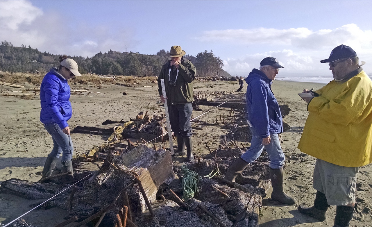
Members of the Astoria-based Maritime Archaeological Society investigate the wreckage, including taking extensive measurements and photos, which will be used in an attempt to identify the original vessel’s name.
Some of the shipwreck’s timbers were first revealed when the bank line eroded approximately 100 yards south of Warrenton Cannery Road in late December, 2009. COASTAL IMAGES|RON AREL