

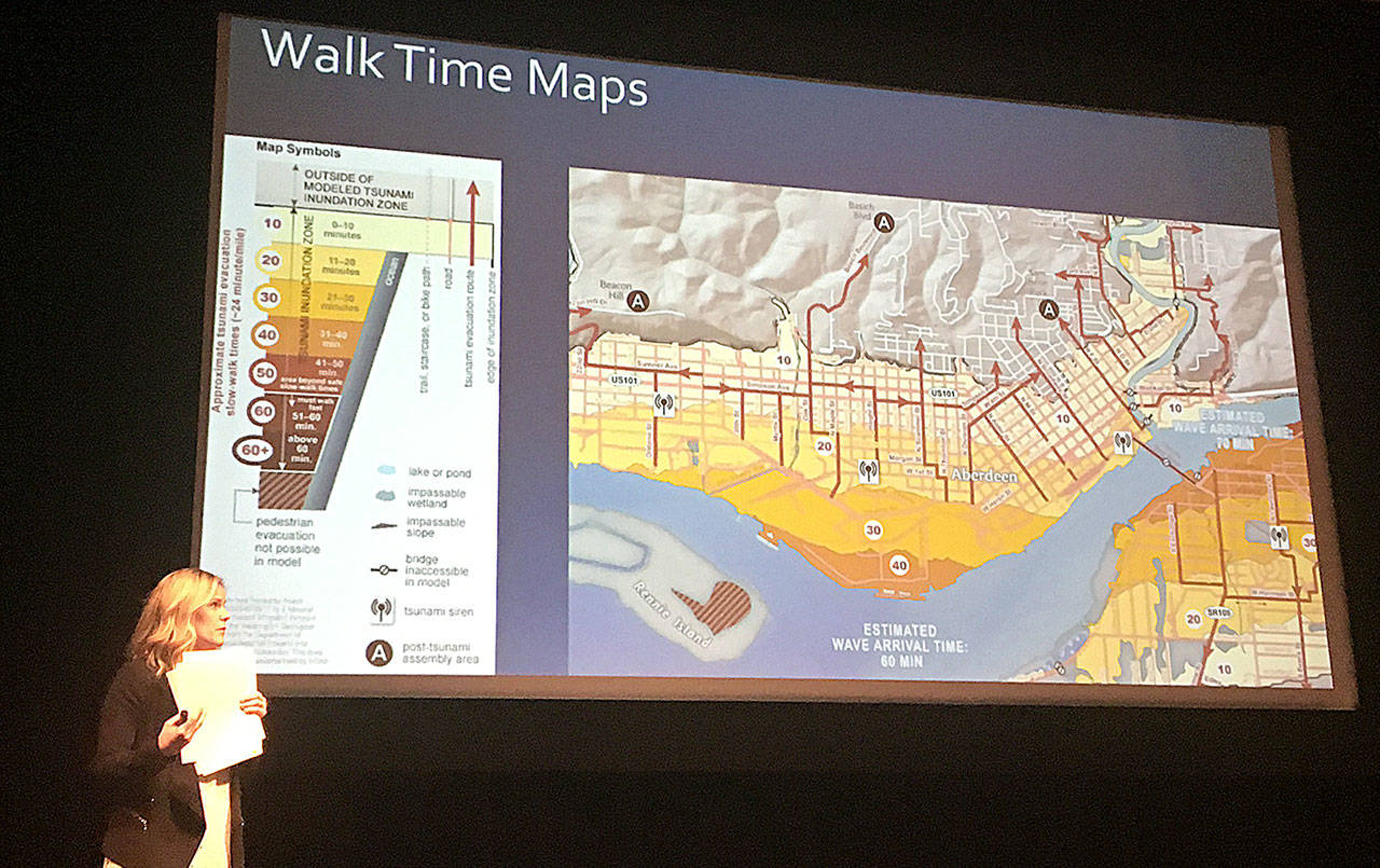
Recently updated tsunami evacuation maps include the estimated time it would take to walk to safety in Aberdeen, Hoquiam and Cosmopolis, and how travel times relate to the expected arrival of the first tsunami wave.
The maps, unveiled April 5 by the Department of Natural Resources, were discussed at the Tsunami Road Show presentation Wednesday at Aberdeen High School.
In a major tsunami event, evacuation routes to the safety of high ground would likely be impassable by vehicle due to downed power lines, water over roadways and damage to roadways and bridges. Because of that, evacuating by foot will likely be the best chance of reaching safety in time, agreed the panel Wednesday.
Hannah Cleverly, Deputy Director of Emergency Management for Grays Harbor County, said the estimated times were based on casual walking speeds, the same used to time crosswalk signals — about 2.25 mph, or a mile every 24 minutes.
When teamed with inundation maps, which show the expected arrival time and level of a Cascadia tsunami event — a worst case scenario created by a Magnitude-9 or greater earthquake — residents can see the nearest route to high ground and how long it would take to walk there.
Timing
The maps show a tsunami would arrive in Aberdeen about an hour after an earthquake is first detected. Pedestrian evacuation times of 10-20 minutes cover much of the city, while areas around the Port of Grays Harbor are closer to 30 minutes from high ground.
In South Aberdeen, a walking evacuation from West Curtis Street will take about 40 minutes, with a first wave arrival time of about 70 minutes. Much of South Aberdeen lies in the 10-20 minute time frame. In Cosmopolis, with its closer adjacent high ground, walking evacuation times are mostly less than 20 minutes, according to the maps.
Evacuation times on foot in Hoquiam range mostly from 20 to 40 minutes, with an estimated wave arrival about 50 minutes from the initial earthquake. North of Emerson Avenue it’s about 10 minutes, between there and the Simpson Avenue Bridge about 20 minutes, and south of there 30-40. At Bowerman Airport times are estimated at 40 to 50 minutes.
Evacuation routes are clearly marked on the map, and all lead toward higher ground, above the elevation of the inundation zone. Survival hinges on preparedness, knowing your routes and heading for safety as soon as the shaking stops enough you can safely move, said Maximilian Dixon with the Washington State Emergency Management Division.
“Remember, 60 minutes goes really fast,” said Cleverly. “When you feel that quake, get to high ground as soon as you can.”
Evacuation towers
There is still just one tsunami evacuation tower on the coast, atop the Ocosta Elementary School gym near Westport. The Shoalwater Bay Tribe is in the process of building its own with the help of a $2.2 million FEMA grant. Dixon said that tower will hold several hundred people and will be available for use by tribal members and their non-tribal neighbors.
Aberdeen, Ocean Shores and Westport all have active grant applications with FEMA to build vertical evacuation towers, said Dixon.
About 20 towers are needed in Ocean Shores alone, by some estimates. Dixon said a study is underway to find out just how many towers are needed along the coast.
Online resources
These updated maps can be accessed online at dnr.wa.gov/programs-and-services/geology/geologic-hazards/tsunamis/evacuation. Walk time maps are only available for Aberdeen, Cosmopolis and Hoquiam at the time, but detailed evacuation maps for other parts of Grays Harbor and Pacific counties can also be found on the web page.
There is an interactive map available at geologyportal.dnr.wa.gov/#tsunami_evac, tipped Carrie Garrison-Laney with the Washington Sea Grant.
“You can type in an address and get evacuation information and inundation models,” she said.

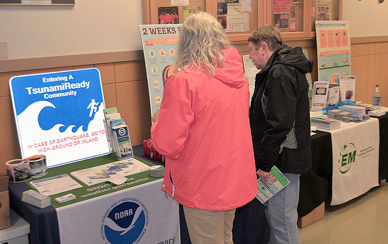
DAN HAMMOCK | GRAYS HARBOR NEWS GROUP People who attended the Tsunami Road Show presentation at Aberdeen High School Wednesday took home a variety of free information on how to prepare for and survive a disaster.
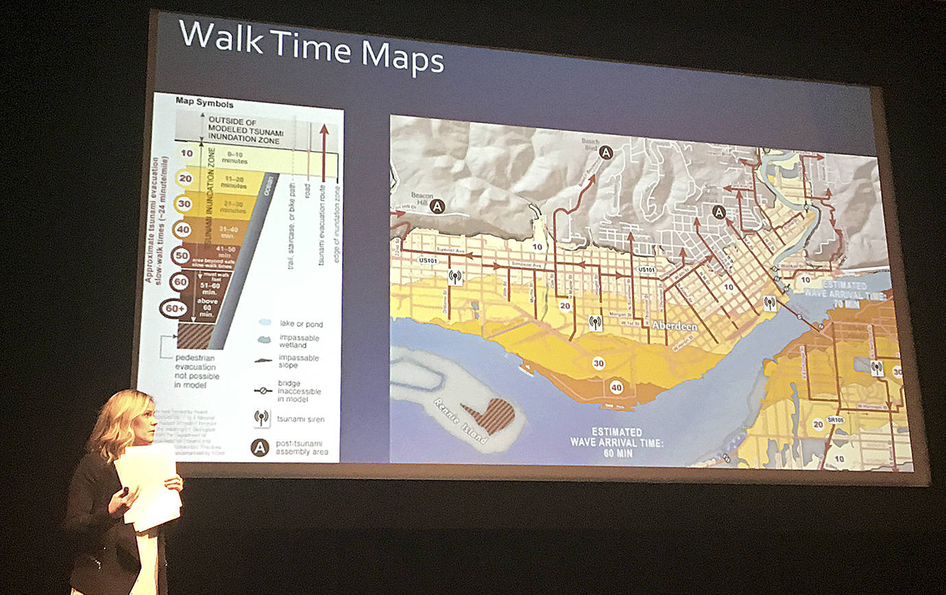
DAN HAMMOCK | GRAYS HARBOR NEWS GROUP A pedestrian tsunami evacuation map for Aberdeen, updated in early April, shows how long it would take to reach high ground on foot. Hannah Cleverly, Grays Harbor County Deputy Director of Emergency Management, explains it at the Tsunami Road Show Wednesday.
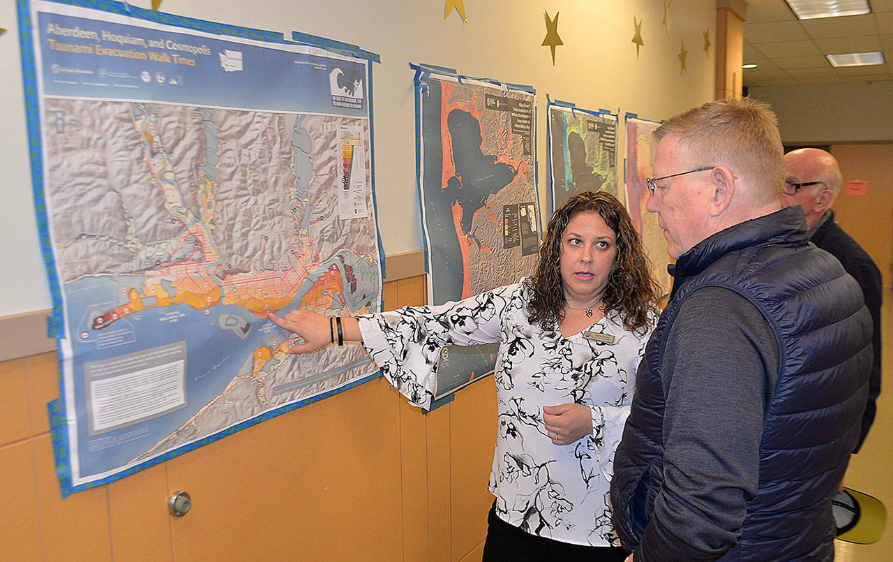
DAN HAMMOCK | GRAYS HARBOR NEWS GROUP Keily Yemm, Tsunami Program Coordinator with the Washington State Military Department, shows the recently updated walking time tsunami evacuation route map for Aberdeen to Grays Harbor County Commissioner Randy Ross.

DAN HAMMOCK | GRAYS HARBOR NEWS GROUP Washington State Emergency Management Division earthquake program manager Maximilian Dixon talks tsunami and earthquake preparedness at the Tsunami Road Show in Aberdeen Wednesday.
DAN HAMMOCK | GRAYS HARBOR NEWS GROUP People who attended the Tsunami Road Show presentation at Aberdeen High School Wednesday took home a variety of free information on how to prepare for and survive a disaster.
DAN HAMMOCK | GRAYS HARBOR NEWS GROUP A pedestrian tsunami evacuation map for Aberdeen, updated in early April, shows how long it would take to reach high ground on foot. Hannah Cleverly, Grays Harbor County Deputy Director of Emergency Management, explains it at the Tsunami Road Show Wednesday.
