
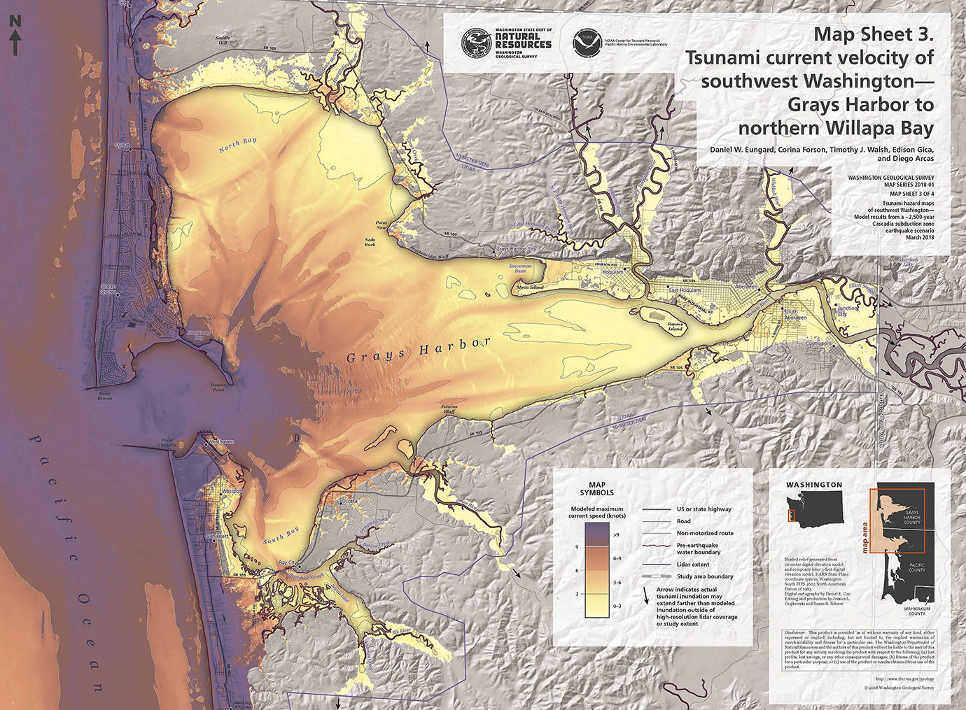
New tsunami inundation maps released by the State Department of Natural Resources Monday show a magnitude 9.0 earthquake off the coast of Grays Harbor and Willapa Bay could create a tsunami that could hit the outer coastline at more than 40 mph with waves ranging from 20 to 60 feet for at least 12 hours before subsiding.
Put an emphasis on the “could.”
The numbers used in the most recent study are based on the worst known event of its kind to ever happen in the area, said Joe Smiley, spokesman with the Department of Natural Resources.
“We have had one instance of something close to this size and it was about 8,000 years ago,” he said. The previous modeling study was based on data from the estimated 9.0 earthquake and tsunami of 1700.
Smiley hesitates to call the report a “worst case scenario” because, when it comes to nature, “you never know.” But the current model was used for the new maps to show the areas most likely to remain safe if the biggest of the big ones hits.
The report, authored by five scientists with the Washington Geological Survey, used something called finite-difference modeling to create the maps. The report said while areas on the outer coast would see surges to 60 feet, inside both Grays Harbor and Willapa Bay, waves would be in the 10 feet or less range.
When a magnitude 9.0 earthquake hits the Cascadia Subduction Zone, about 50 miles off the coast, it causes “slip,” meaning sediment off the coast plunges off the shelf into the sea, creating turbulence and a tsunami. The amount of slip factored in to these new maps is significantly higher than that used in previous surveys.
The report indicates a tsunami after a magnitude 9.0 earthquake would give people along the coast just 15 to 20 minutes to get to high ground before the wave hits. The maps, generated by using computer models of earthquake-caused tsunamis from nearby seismic forces, become useful in planning and marking evacuation routes well ahead of a tsunami event as there are only minutes for locals to evacuate.
Such an event would create significant navigational hazards for maritime operations for more than 24 hours after the quake, according to the report. Waves would remain high for the first 12 hours, then diminish over the next 12 hours.
The report states the modeling method used for the maps does not account for tidal effects or minor topographical changes that would locally modify the impact of tsunami waves. Because of that, the report states the modeling should not be used for site-specific tsunami inundation assessment or for determining effects on structures in any particular area, but as a tool for evacuation and recovery planning.
The report states that the new modeling method more closely mimics likely scenarios based on historical analysis of previous tsunamis. The most recent model provides scenarios that are much less likely to be exceeded than the previous model, it claims.
There are some factors within the models that are variables, including the amount the sea floor is altered during an earthquake. The new model factors in a quake and assumes an understood slip distribution and sea floor deformation, which is difficult to predict. The report suggests a lower slip amount would generate a smaller tsunami than the most recent model in the report. Also, some gaps in elevation data available for locations like the Port of Grays Harbor and Porter Point on the south end of Willapa Bay east of Long Beach, which would be expected to show up as inundated on the new maps, are not.
“These maps also bring us into line with the seismic building code,” said Smiley. “We make sure our evacuation structures are based on that.”
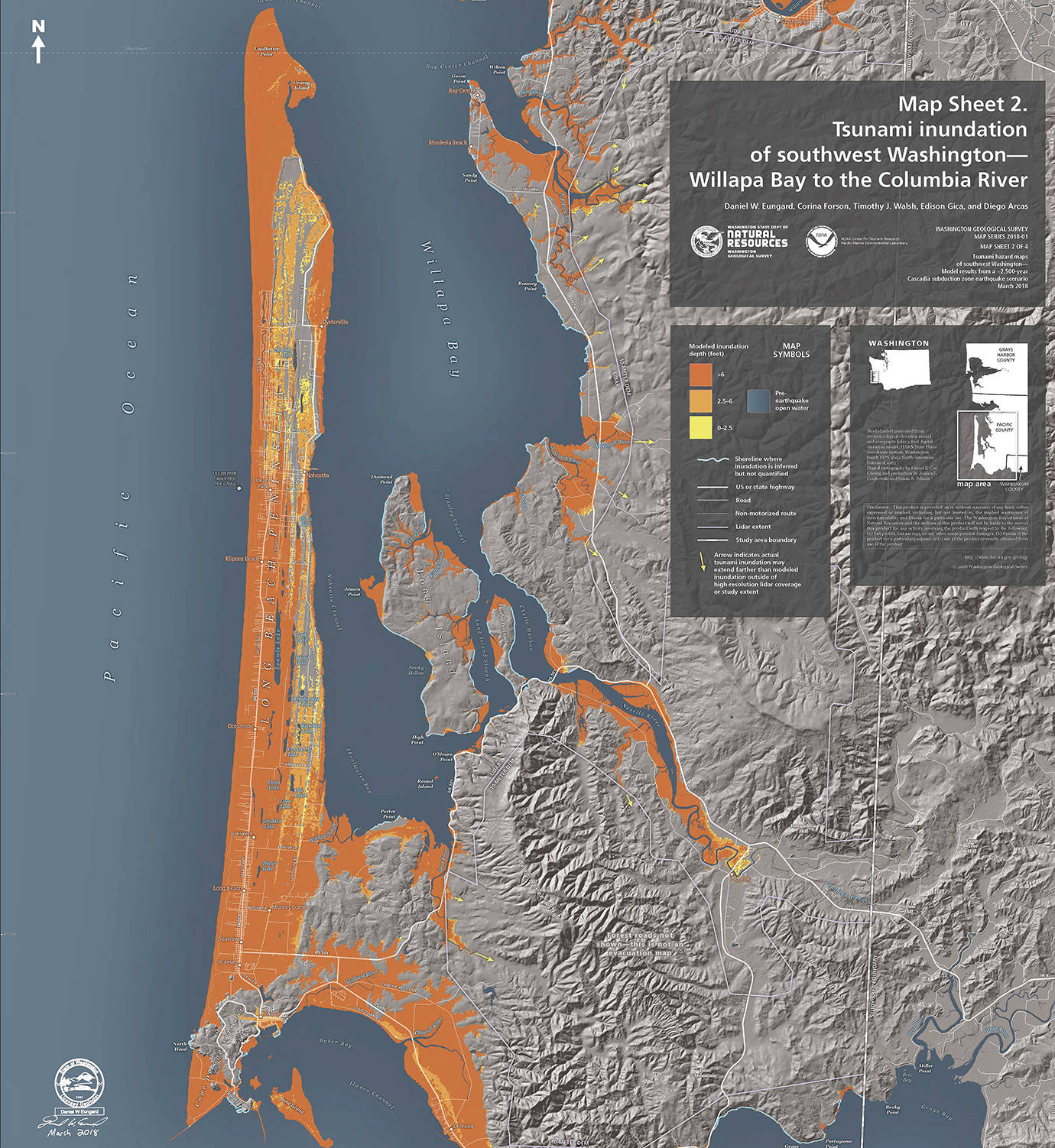
WASHINGTON GEOLOGICAL SURVEY The impacts of a magnitude 9 earthquake off the coast of the Long Beach Peninsula could include waves to 60 feet moving at more than 40 mph.
