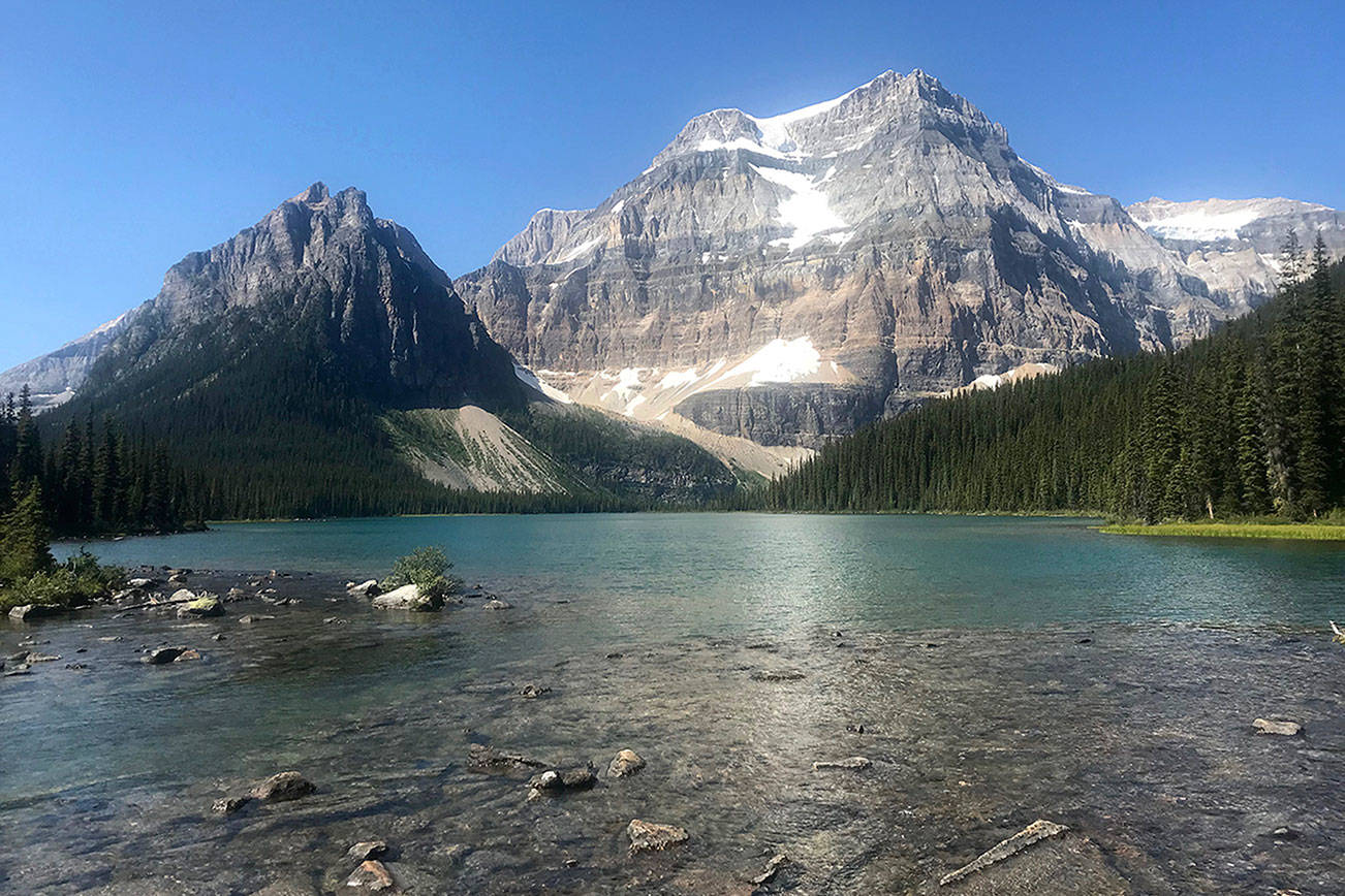
With glaciers draped over towering mountains, meadows teeming with wildflowers and an abundance of turquoise lakes, Banff National Park is widely considered one of the ultimate places to go backpacking.
After completing a four-day hike in the heart of this Canadian national park earlier this month, I found myself questioning why I never knew about the Canadian Rockies before. A major reason I moved to the Pacific Northwest was for the hiking opportunities, and while living here it’s been easy to assume the Olympic Mountains and the North Cascades were unbeatable in terms of alpine scenery.
But Banff — located 90 miles west of Calgary, Alberta — is even more majestic and massive, making for a great backpacking trip.
Lake Louise is the park’s most popular glacial lake, which means it’s usually packed with tourists. I chose a path less traveled on this hike with my parents. We decided on a route covering about 33 miles, starting and ending at the Redearth Creek trailhead, just off the Trans-Canada Highway. This four-day trek allowed us to enjoy amazing mountain landscapes while avoiding the big crowds.
To get there, I flew to Calgary, which is an easy 1- or 2-hour flight from Seattle; from there, it’s about a 90-minute drive to Banff. You could also drive all the way there from Grays Harbor on either of two fairly direct 12- to 13-hour routes. One involves taking I-5 from Olympia deep into Canada, then heading east on the Trans-Canada Highway. The other takes I-90 from Seattle to Coeur d’Alene, then hooks north on I-95 into Canada.
Day One: 12.9 miles
Redearth Creek Trail to Shadow Lake
This trail starts off in the lowlands, meandering through a sea of skinny pine trees. After 4 miles we were in a valley, following a clear stream on a trail where you might happen to encounter grizzly bear feces — or even the bear itself.
As we gained elevation and the trees got sparser, the wildflowers became more prevalent. In particular, Indian paintbrush was everywhere, in colors ranging from bright pink to dark red. There also was plenty of Western pasqueflower, which in August resembled the Truffula trees from Dr. Seuss’ “The Lorax.”
Getting to Shadow Lake Campground was another 4 miles through a tough uphill section. (Make sure to turn right at the first intersection with the Shadow Lake Trail.) The campsite has a prime location right next to an enormous meadow with yellow flowers in the summer, and a great view of the impressive Mount Ball in the distance.
Shadow Lake was a major highlight of our trip. I sat by it for a long time and admired the gigantic mountain shaped by glaciers.
Day Two: 6.6 miles
Shadow Lake Trail to Ball Pass Junction
The second day started out fairly easy, walking just about 3.2 miles on a mostly flat trail to the Ball Pass Junction Campsite. Since that was such a short hike, we decided to take a day trip from our campsite to the top of Ball Pass — without our heavy backpacks.
That trail winds up onto the rocks above the treeline. It’s tough, but it gave me a strong sense of accomplishment. Plus, it’s relatively safe to drink the stream water up there; it comes straight from the glaciers and tastes incredible after a difficult climb.
Martens, which are related to ferrets, are also common in this area. You might spot some looking back at you as they scurry up a tree.
Day Three: 8.2 miles
Whistling Valley Trail to Pharaoh Creek Trail
This day was the most challenging — and the most rewarding. We hiked out over Whistling Pass before the trail turned into a “harrowing downhill,” as one person we passed called it.
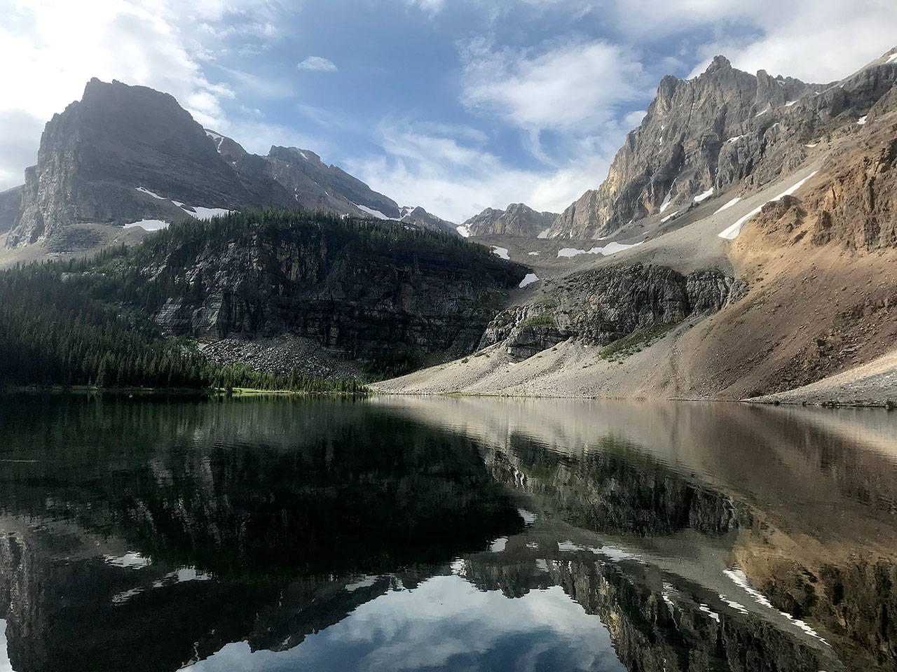
The most memorable part of the day was arriving at Haiduk Lake that morning. Aside from a couple hiking the Continental Divide, it was devoid of other people, and it was strikingly beautiful. In one corner is a waterfall, yet the lake was nearly still, giving a mirror image of the giant mountains above.
From there, the path became a strenuous uphill until we reached Whistling Pass, which is named for the multitude of hoary marmots that are usually whistling there.
The top of that pass is also a good spot to search for fossils. While walking the trail, we picked up several rocks to find little indentations from the remains of some of the planet’s earliest creatures — ocean dwellers, like trilobytes and sea sponges.
Day Four: 9.1 miles
Pharaoh Creek Trail back to Redearth Creek Trail
Pharaoh Creek Campground isn’t as spectacular as the previous sites, but I did get to have some fun conversations.
One really nice element of Banff’s trails is there are communal areas for cooking at the established campsites along the way.
During breakfast, a young woman from Japan joined us. She was taking a personal vacation from her job as a tour guide for the hundreds of Japanese tour buses that go through Banff.
Since I studied Japanese in college, it was a great glance to practice my speaking skills, and we chatted about her favorite hiking areas in Japan. The communal nature of Banff’s campgrounds is something I wish parks in the U.S. would emphasize more.
Soon after leaving the campsite, the trail winds down into the valley until you’re right next to Pharaoh Creek.
After reconnecting with Redearth Creek Trail, it was a few more miles back to the Trans-Canada Highway — which gave my mom ample time to think about a much-anticipated dip in the hot tub at the hotel.
Louis Krauss, a Daily World reporter for the past two years, left the Pacific Northwest this week to take a job at The Daily Record in his hometown of Baltimore.
* * *
A few notes
Campsites are tough to get at Banff; you generally have to inquire several months before your trip. But they’re easier to reserve on our chosen route than in the more popular areas. To plan your hike and reserve campsites, go to the Parks Canada website and navigate to Banff.
One really nice element of Banff’s trails is there are communal areas for cooking at the established campsites along the way, as well as lockers where hikers can store food overnight to avoid worrying about bears.
As you plan for this trip, I recommend trying to conserve weight in your backpack as much as possible. There’s no need to take more than one change of clothes or too much extra food. My pack was 40 pounds.
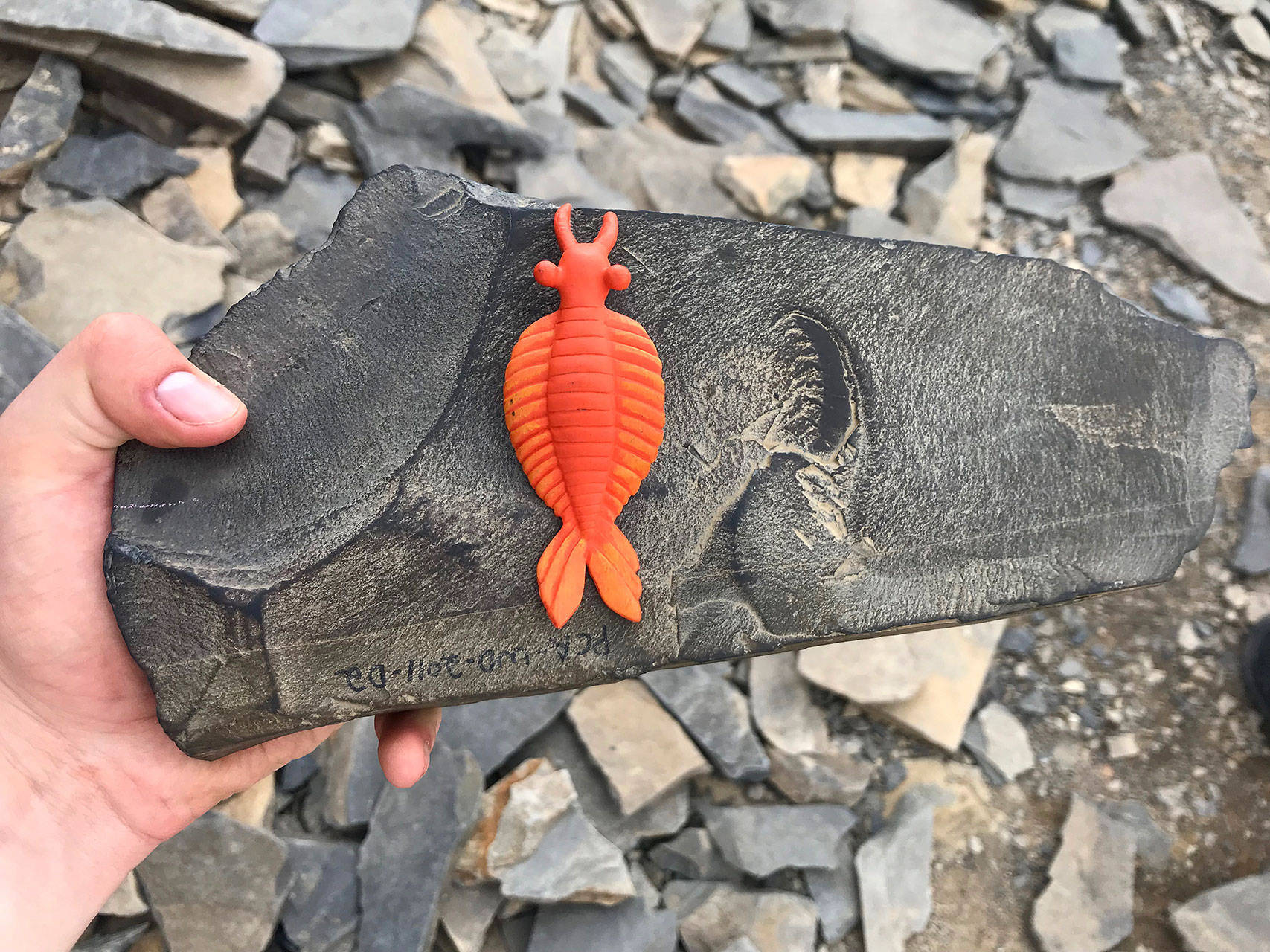
Louis Krauss | Grays Harbor News Group A fossil of Anomalocaris, or abnormal shrimp, at the Burgess Shale site in the Canadian Rockies, where numerous fossils as old as 508 million years can be found. The orange toy is a replica of what the creature might have looked like.
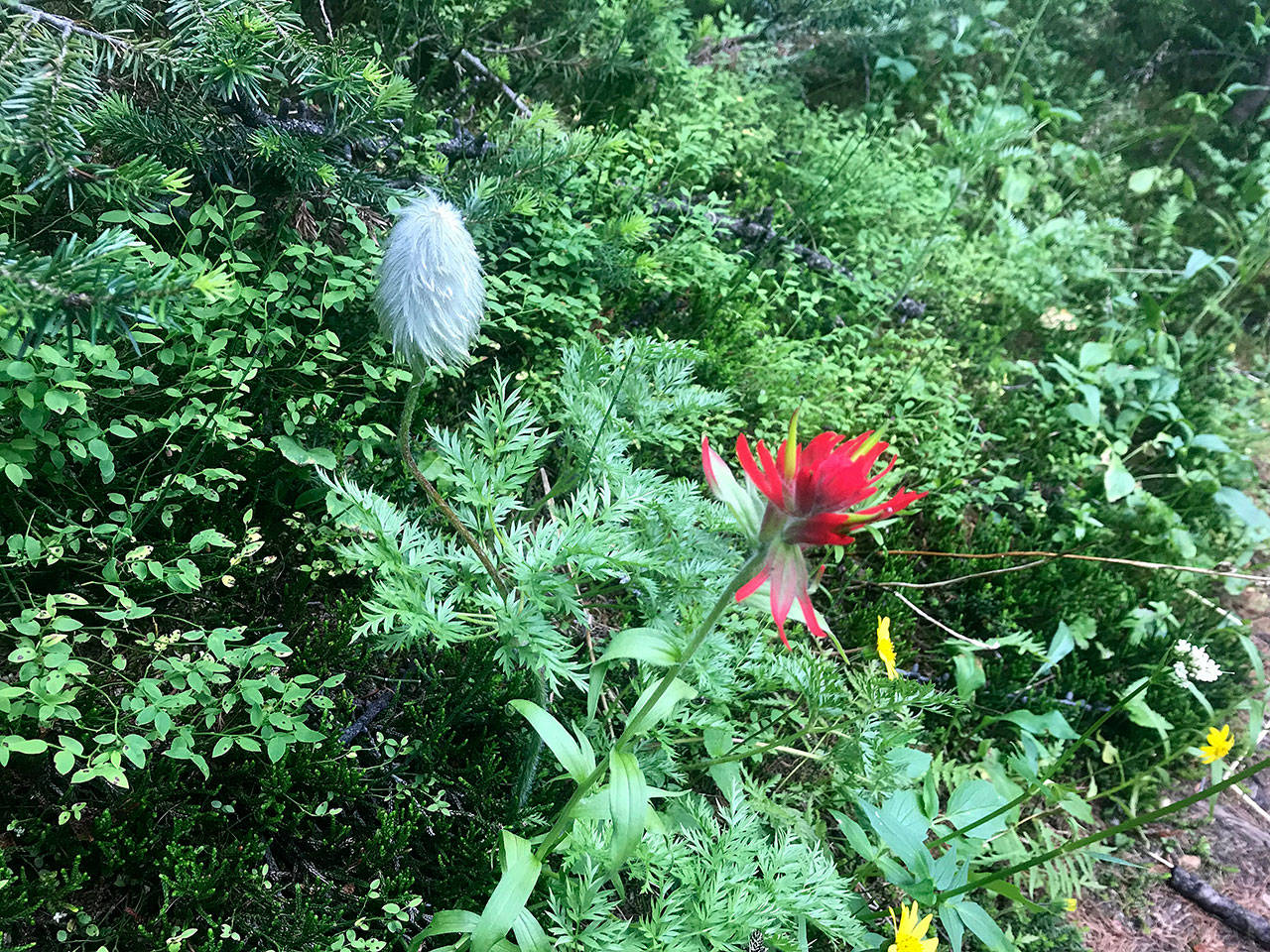
A Western pasqueflower, left, and an Indian paintbrush
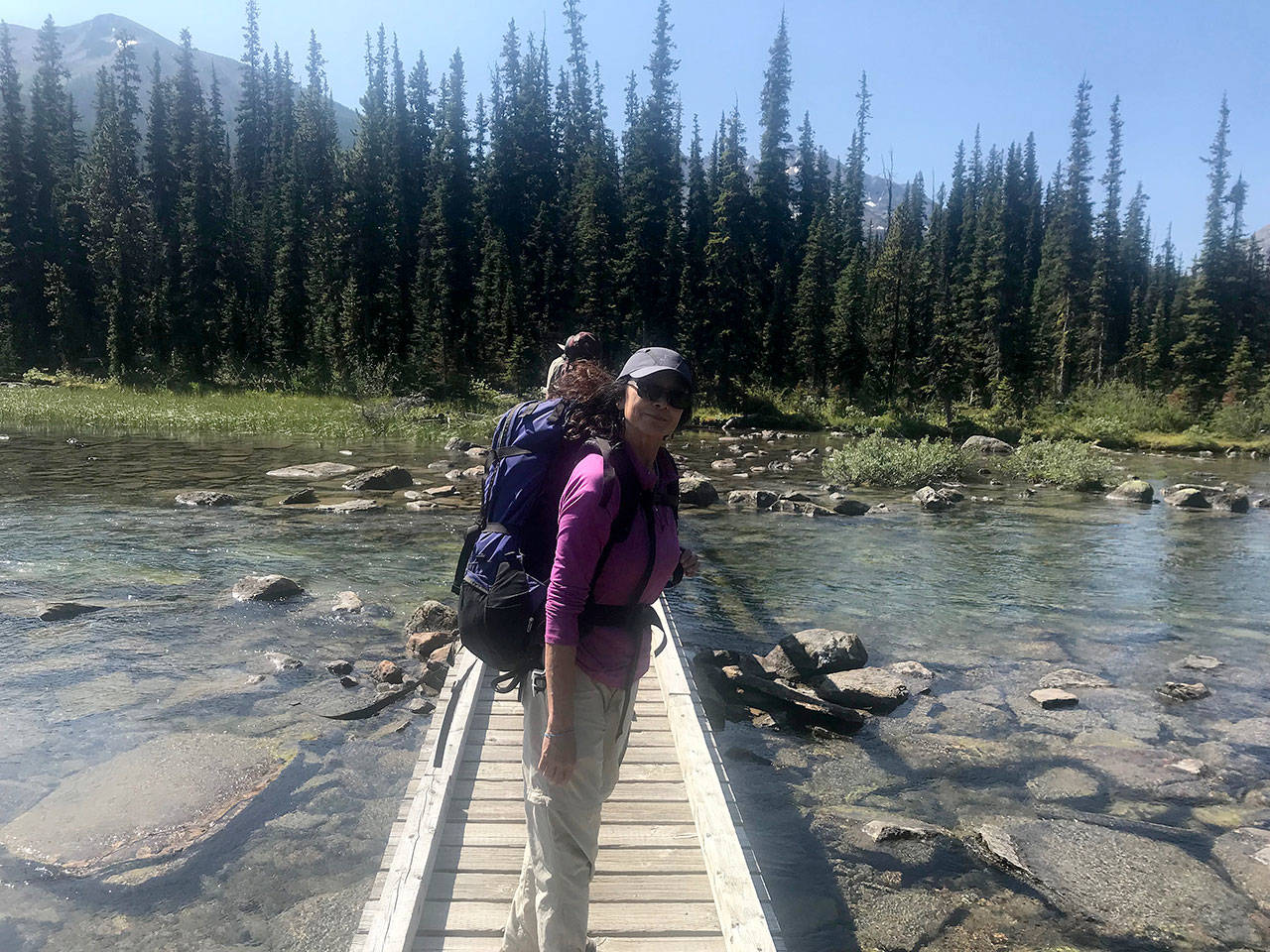
Louis Krauss | Grays Harbor News Group The author’s mother, Fern Shen, crosses the bridge at Shadow Lake in Banff National Park.
Day Three: Haiduk Lake